Birmingham city centre contains one of the United Kingdom’s most concentrated collections of historic landmarks, museums, Victorian architecture, public squares, canals, shopping districts, and cultural institutions. Efficient planning allows visitors to experience the city’s major attractions within walking distance while understanding how Birmingham developed from a medieval market town into Britain’s industrial powerhouse and a modern cultural destination.
- Why is Birmingham city centre easy to explore on foot?
- Which attractions should visitors prioritise first?
- How did Birmingham’s historical development shape today’s visitor experience?
- What role do Birmingham’s museums play in understanding the city?
- How do Birmingham’s canals improve an efficient sightseeing itinerary?
- Which historical districts deserve additional time?
- How does public transport support efficient sightseeing?
- What architectural styles define Birmingham city centre?
- Why do Birmingham’s public squares matter historically?
- How can visitors combine history, culture, and modern attractions in one itinerary?
- Why does efficient planning improve the Birmingham visitor experience?
Located in England’s West Midlands, Birmingham grew rapidly during the eighteenth and nineteenth centuries through metalworking, manufacturing, engineering, and canal transport. Much of that industrial heritage survives alongside contemporary developments, creating an accessible uk/local/city-centre/">city centre where centuries of history coexist within a relatively compact area. The city’s pedestrian-friendly layout, integrated public transport network, and clearly defined cultural quarter make it possible to maximise sightseeing time while minimising unnecessary travel.
Whether visiting for a single day or several days, understanding Birmingham’s geography, transport system, and historical development helps create an efficient itinerary that balances major attractions with lesser-known cultural sites.
Why is Birmingham city centre easy to explore on foot?
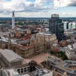
Birmingham city centre covers a compact area where major museums, historic buildings, shopping streets, public squares, canals, and transport hubs sit within comfortable walking distance. Careful route planning reduces travel time while allowing visitors to experience the city’s historical evolution through connected cultural landmarks.
Unlike many large British cities, Birmingham’s principal attractions cluster around several interconnected districts. Walking between most major landmarks typically requires between five and fifteen minutes, making pedestrian exploration the most efficient option for first-time visitors.
The city centre revolves around several historic zones. Victoria Square functions as the civic heart of Birmingham. Nearby Chamberlain Square contains important cultural institutions, while Colmore Row preserves much of Birmingham’s Victorian commercial architecture. The Jewellery Quarter lies just northwest of the centre, and the historic canal network extends through Brindleyplace and Gas Street Basin.
Extensive pedestrianisation has improved accessibility throughout the central district. Wide pavements, public squares, canal towpaths, and clearly marked routes allow visitors to navigate safely between attractions without relying heavily on vehicles.
Modern regeneration projects have preserved significant historical buildings while improving public spaces, allowing visitors to appreciate Birmingham’s architectural continuity from the eighteenth century through the twenty-first century.
Which attractions should visitors prioritise first?
Visitors achieve the most efficient sightseeing by beginning with Birmingham’s central historic district before expanding toward nearby cultural quarters, canal areas, museums, and heritage neighbourhoods. This approach minimises repeated walking and follows the city’s historical development chronologically.
Starting at Birmingham New Street Station provides immediate access to many principal attractions.
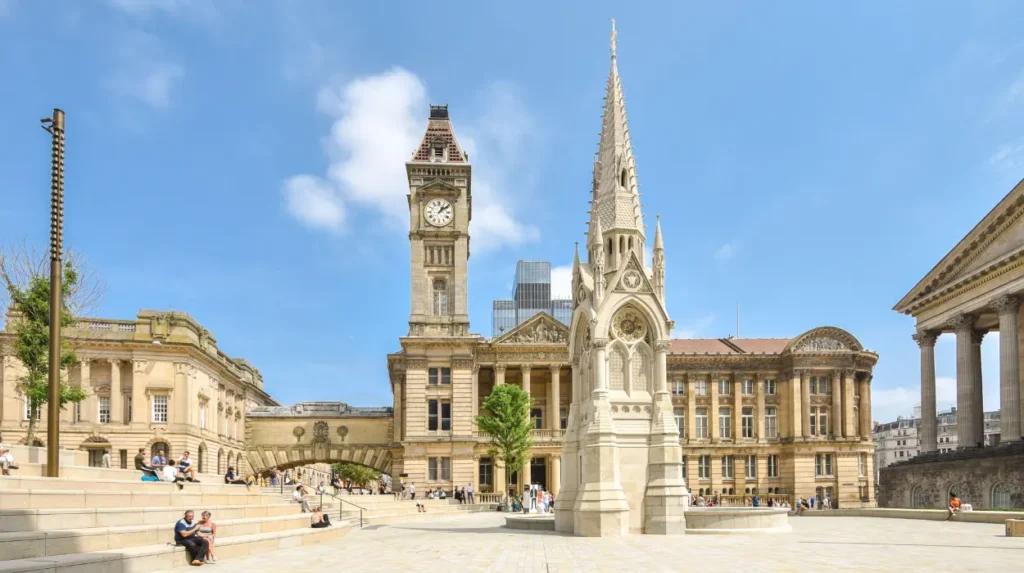
Victoria Square serves as an excellent orientation point. The square contains important civic buildings including Birmingham Town Hall and the Council House. It also offers direct access to nearby museums, galleries, and pedestrian streets.
Chamberlain Square connects several of Birmingham’s most significant cultural institutions within a few minutes’ walk. This concentration of attractions reduces travel time while providing insight into the city’s artistic, political, and educational development.
Moving west toward Centenary Square introduces visitors to Birmingham’s modern civic architecture before reaching the canal district.
The final stage of an efficient walking route often includes the Jewellery Quarter, where preserved industrial buildings demonstrate Birmingham’s international importance in jewellery manufacturing since the eighteenth century.
To experience these historic landmarks in person today, consult our comprehensive [How to Explore Birmingham’s Museums and Cultural Attractions] for itineraries and visiting parameters.
How did Birmingham’s historical development shape today’s visitor experience?
Birmingham’s medieval origins, Industrial Revolution expansion, Victorian civic improvements, twentieth-century reconstruction, and twenty-first-century regeneration created a city centre where successive historical periods remain visible within short walking distances, allowing visitors to explore centuries of urban development efficiently.
Birmingham originated as a small market settlement during the twelfth century. Its central location encouraged commercial growth, while nearby natural resources supported early metalworking industries.
The eighteenth century transformed Birmingham into an internationally recognised manufacturing centre. Entrepreneurs developed workshops producing buttons, buckles, firearms, jewellery, scientific instruments, and precision metal goods.
The Industrial Revolution accelerated population growth dramatically. Between 1700 and 1851, Birmingham expanded from a market town into one of Britain’s largest industrial cities.
Canal construction played a central role in this transformation. The Birmingham Canal Navigations eventually formed one of Britain’s most extensive inland waterway systems, linking local manufacturers with national markets.
Victorian civic leaders invested heavily in public architecture, education, libraries, museums, and public squares. These investments established many of the cultural institutions visitors enjoy today.
Post-war reconstruction introduced modern shopping centres and transport infrastructure, while regeneration since the 1990s restored historic districts and improved public accessibility.
The result is a city where medieval origins, Georgian industry, Victorian civic ambition, and contemporary redevelopment exist within a compact urban landscape.
What role do Birmingham’s museums play in understanding the city?
Birmingham’s museums preserve archaeological discoveries, industrial heritage, fine art, social history, and scientific innovation. Visiting these institutions provides essential historical context that explains how Birmingham became one of Britain’s leading manufacturing and cultural centres across several centuries.
Museums function as historical anchors that connect physical landmarks with documented evidence.
Collections include Roman artefacts discovered around the region, medieval objects, Industrial Revolution machinery, decorative arts, and internationally significant fine art collections.
Industrial exhibits explain Birmingham’s role in manufacturing technologies that influenced global trade during the eighteenth and nineteenth centuries.
Social history galleries document immigration, population growth, housing, education, and working conditions that shaped the city’s diverse communities.
Art collections illustrate changing cultural priorities alongside industrial prosperity, demonstrating how economic success supported public investment in education and artistic institutions.
Scientific collections highlight Birmingham’s contributions to engineering, medicine, chemistry, and technological innovation.
Together these museums create a comprehensive narrative explaining both local development and broader national historical changes.
How do Birmingham’s canals improve an efficient sightseeing itinerary?
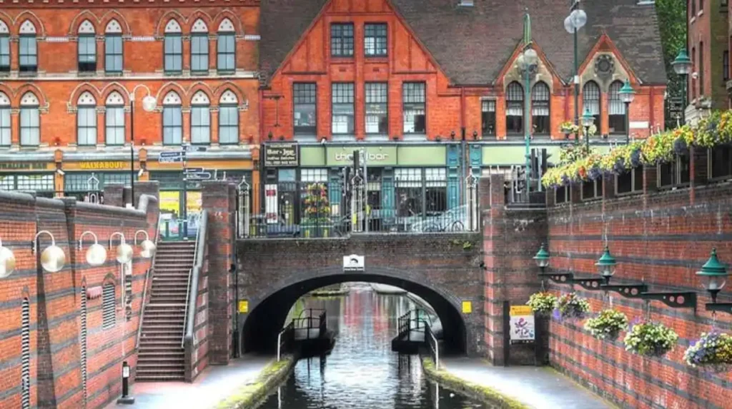
Birmingham’s historic canals provide direct pedestrian routes between major attractions while illustrating the infrastructure that supported Britain’s Industrial Revolution. Canal towpaths combine practical navigation with historical interpretation, reducing walking distances through scenic and historically significant corridors.
Birmingham possesses more than 35 miles of navigable canals within the city, forming part of the extensive Birmingham Canal Navigations.
Originally constructed during the eighteenth century, these waterways transported coal, iron, manufactured goods, and raw materials between factories and national markets.
Today restored towpaths provide level walking routes connecting Brindleyplace, Gas Street Basin, the International Convention Centre, and surrounding cultural venues.
Interpretation panels explain engineering achievements, commercial development, and canal construction techniques.
Historic warehouses, bridges, lock systems, and converted industrial buildings preserve evidence of Birmingham’s manufacturing economy.
Modern cafés, restaurants, hotels, and public spaces now occupy many restored canal-side buildings, demonstrating successful heritage-led regeneration.
Walking beside the canals often proves faster than navigating busy streets while providing uninterrupted historical context.
Which historical districts deserve additional time?
Several historic districts preserve distinct chapters of Birmingham’s development. Spending additional time in these neighbourhoods provides deeper understanding of industrial production, civic administration, commercial growth, and architectural evolution through surviving buildings, streetscapes, workshops, and public monuments.
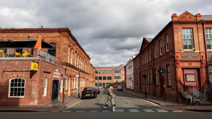
The Jewellery Quarter represents one of Europe’s largest concentrations of historic jewellery workshops.
More than 200 listed buildings survive within the district, preserving workshops, factories, churches, cemeteries, and commercial premises dating largely from the Georgian and Victorian periods.
Colmore Row reflects Birmingham’s nineteenth-century commercial prosperity through banks, office buildings, and civic architecture.
The Cathedral Quarter combines religious heritage with Georgian streets and landscaped public spaces.
Brindleyplace demonstrates successful adaptive reuse of industrial buildings into mixed-use commercial and cultural developments.
Digbeth preserves significant industrial architecture alongside contemporary creative industries, illustrating Birmingham’s continuing economic transformation.
Each district contributes a distinct perspective on the city’s historical development while remaining accessible through short walking routes.
How does public transport support efficient sightseeing?
Birmingham’s integrated transport network combines rail services, tram routes, buses, pedestrian infrastructure, and cycling facilities. Visitors reduce travel time by combining walking with public transport for destinations beyond the compact central historical district.
Birmingham New Street Station serves as the city’s principal railway hub, connecting regional and national rail services.
Additional stations including Snow Hill and Moor Street improve access to different parts of the city centre.
The West Midlands Metro tram system links central Birmingham with surrounding districts while reducing dependence on road traffic.
Frequent local bus services connect attractions beyond comfortable walking distance.
Clearly marked pedestrian routes encourage exploration between closely grouped landmarks.
Cycling infrastructure has expanded through recent regeneration programmes, providing another efficient transport option.
Integrated ticketing across multiple transport modes simplifies movement throughout the city.
Visitors planning multiple destinations benefit from combining walking with rail or tram travel rather than relying exclusively on private vehicles.
What architectural styles define Birmingham city centre?
Birmingham city centre displays medieval foundations, Georgian planning, Victorian civic architecture, Edwardian commercial buildings, post-war reconstruction, and contemporary regeneration. These architectural layers document changing political priorities, economic growth, technological innovation, and urban planning across more than eight centuries.
Relatively little medieval architecture survives due to industrial expansion and later redevelopment.
Georgian buildings illustrate Birmingham’s emergence as a prosperous manufacturing town during the eighteenth century.
Victorian architecture dominates much of the historic core. Public investment created libraries, museums, council buildings, educational institutions, and commercial offices displaying Gothic Revival, Classical Revival, and Renaissance Revival influences.
Edwardian commercial buildings continued this architectural confidence through increasingly elaborate façades.
Post-war rebuilding introduced modernist planning principles following wartime damage and urban renewal initiatives.
Since the late twentieth century, conservation programmes have restored numerous historic buildings while integrating contemporary architecture.
This architectural diversity provides visual evidence of Birmingham’s continuous adaptation across changing historical periods.
Why do Birmingham’s public squares matter historically?
Public squares represent Birmingham’s civic identity, political development, cultural investment, and urban planning. These open spaces commemorate influential leaders while providing accessible gathering places that continue supporting public events, education, and community life.
Victoria Square developed during nineteenth-century civic improvements that transformed Birmingham into a modern municipal centre.
Statues commemorate political reformers, industrial leaders, and public servants whose contributions influenced Birmingham’s development.
Chamberlain Square honours Joseph Chamberlain, whose municipal reforms expanded education, public health, libraries, and infrastructure.
Centenary Square reflects twentieth-century and twenty-first-century civic aspirations through cultural institutions, public art, and event spaces.
These squares remain important locations for festivals, commemorations, public exhibitions, and civic ceremonies.
Landscape design, monuments, fountains, and surrounding architecture collectively express Birmingham’s civic history.
Their close proximity enables visitors to understand Birmingham’s political and administrative evolution within a relatively short walking distance.
How can visitors combine history, culture, and modern attractions in one itinerary?
An efficient itinerary integrates historical landmarks, museums, canals, shopping streets, public spaces, architecture, and contemporary cultural venues. Following Birmingham’s historical geography creates a balanced visitor experience while maintaining logical walking routes throughout the city centre.
Begin early at Birmingham New Street Station before crowds increase.
Walk toward Victoria Square to understand Birmingham’s civic development.
Continue through Chamberlain Square to explore major cultural institutions.
Proceed west to Centenary Square and nearby canal districts where industrial heritage meets contemporary regeneration.
Follow canal towpaths toward Brindleyplace before returning through commercial districts that illustrate Birmingham’s economic transformation.
Allocate additional time to the Jewellery Quarter, where industrial history survives within one of Britain’s best-preserved manufacturing neighbourhoods.
Complete the day with visits to museums that reinforce historical knowledge gained while exploring the city’s streets.
This chronological and geographical sequence minimises repeated routes while connecting historical themes with surviving buildings and cultural institutions.
Why does efficient planning improve the Birmingham visitor experience?
Efficient planning enables visitors to understand Birmingham’s complete historical narrative while reducing unnecessary travel. Structured itineraries connect architecture, museums, canals, public spaces, transport, and cultural institutions into a coherent exploration of Britain’s second-largest city’s enduring historical significance.
Birmingham’s development reflects major themes in British history including medieval commerce, industrialisation, engineering innovation, civic reform, immigration, education, and urban regeneration.
Its compact city centre enables visitors to experience these interconnected themes without extensive travel between attractions.
Understanding historical chronology also improves appreciation of surviving landmarks. Museums explain industrial innovation. Public squares demonstrate civic ambition. Canal networks illustrate commercial infrastructure. Victorian buildings reveal economic prosperity. Contemporary regeneration highlights heritage preservation alongside modern development.
Efficient routes also encourage longer engagement with individual attractions instead of spending valuable time navigating between destinations.
As Birmingham continues investing in conservation, public transport, museums, and cultural programming, its city centre remains one of Britain’s most accessible urban heritage destinations. Visitors who combine historical understanding with practical route planning gain a richer appreciation of the city’s transformation from medieval market settlement to internationally recognised industrial metropolis and vibrant modern cultural capital.
Can you explore Birmingham city centre on foot?
Yes. Most of Birmingham’s major attractions are within a compact city centre, making it easy to walk between landmarks such as Victoria Square, Chamberlain Square, Centenary Square, the Bullring, and the canal district. Many attractions are only 5–15 minutes apart on foot.