Birmingham city centre contains one of the densest clusters of civic, religious, commercial, and industrial heritage sites in the English Midlands. Within a relatively compact area, visitors can move from the medieval parish core around St Martin’s to Georgian churchyards, Victorian municipal buildings, canal-era infrastructure, Edwardian shopping streets, and 21st-century cultural landmarks. This concentration makes central Birmingham one of the most efficient urban heritage destinations in Britain for a one-day or two-day visit.
- What makes Birmingham city centre efficient for sightseeing?
- Where should a first-time visitor start near Birmingham city centre?
- Why is St Martin in the Bull Ring historically important?
- Which civic buildings explain Birmingham’s Victorian rise?
- How does Victoria Square help visitors understand Birmingham’s civic identity?
- Why is St Philip’s Cathedral essential on a Birmingham city centre route?
- What do Birmingham’s museums reveal about the city’s history?
- How do the canals and Brindleyplace fit into Birmingham’s historic story?
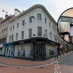
- Is the Jewellery Quarter close enough to include with Birmingham city centre attractions?
- How can visitors plan the most efficient walking route through Birmingham city centre attractions?
- Why do Birmingham city centre attractions matter beyond tourism?
The area matters because Birmingham’s growth was unusually fast and unusually varied. It developed from a planned medieval market town into a manufacturing and commercial centre, then into a Victorian municipal powerhouse, and later into a post-industrial city focused on retail, culture, education, and tourism. The surviving attractions around the centre reflect those phases directly. Churches, public squares, arcades, museums, canals, railway approaches, and industrial quarters still show how the city changed over eight centuries.
This guide explains how to visit Birmingham city centre attractions efficiently while also understanding their historical significance. It focuses on places that are practical to combine on foot, grouped by geography and chronology, so that visitors can see the city’s main landmarks without wasting time crossing back and forth.
What makes Birmingham city centre efficient for sightseeing?
Birmingham city centre is efficient for sightseeing because its main attractions sit within a walkable historic core linked by pedestrian streets, canal routes, tram stops, and major rail stations. Medieval, Georgian, Victorian, and modern landmarks can be combined into one coherent route with minimal travel time.
The central area works well because Birmingham’s principal attractions are not scattered across a vast metropolitan landscape. Instead, they cluster in several adjoining zones: the Bullring and St Martin’s in the medieval core; Victoria Square and Chamberlain Square in the civic core; St Philip’s Cathedral and Colmore Row in the Georgian and commercial core; the Library of Birmingham and Centenary Square in the modern cultural quarter; and the canal, Brindleyplace, and Jewellery Quarter fringe to the west and north-west.
This geography reflects Birmingham’s historical growth. The medieval town centred on markets and parish life around the Bull Ring. The Georgian period expanded northward around St Philip’s and St Paul’s. The 19th century created a civic heart around the Town Hall, Council House, and later museums and commercial streets. Industrial infrastructure followed the canals and railways. Modern redevelopment then tied these areas together through pedestrianisation, station rebuilding, and public-realm projects.
For visitors, that means the city can be understood as a sequence rather than as disconnected stops. A practical route can begin at Birmingham New Street or Moor Street station, move through the Bullring, continue to St Martin’s and the markets, then climb into the civic and cathedral quarter before ending at the canals, Library, or Jewellery Quarter. The route follows the historical expansion of Birmingham itself.
Birmingham City Council’s city-centre planning documents also identify this same core structure. They describe the city core as the civic and retail heart of Birmingham, linking Victoria Square, Chamberlain Square, the Bullring, St Philip’s Cathedral, and surrounding commercial streets in a primary walking zone. Those same documents note that the medieval street pattern still survives in parts of the core and that the canal system shaped later industrial expansion. ([Birmingham City Council][1])
Where should a first-time visitor start near Birmingham city centre?
A first-time visitor should start at the Bullring and St Martin’s because this area marks Birmingham’s medieval origin, sits beside New Street and Moor Street stations, and provides the clearest entry point into the city’s historic timeline, retail core, and major pedestrian routes.
Starting at the Bullring gives immediate access to the oldest continuously important part of Birmingham. The name “Bull Ring” refers to the historic market area that developed around the town’s medieval market rights. Birmingham was established as a planned market settlement in the 12th century, and this district remained its commercial centre for centuries. Although the architecture visible today is largely modern or Victorian, the street pattern and market function preserve the logic of the earlier town.
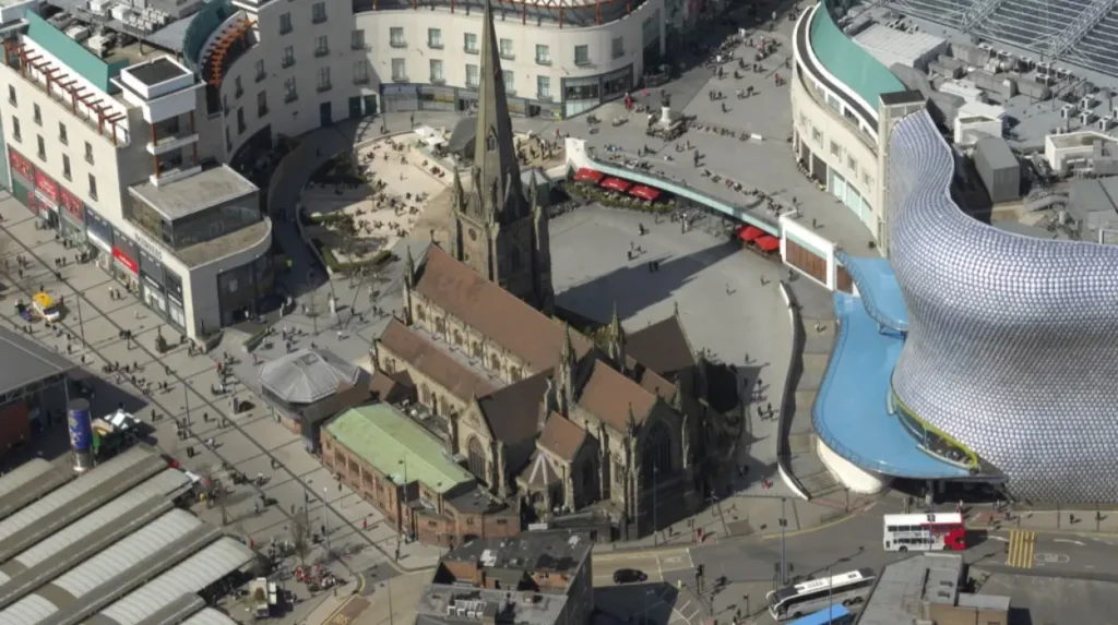
The key monument here is St Martin in the Bull Ring, the ancient parish church of Birmingham. The church stands on a site with origins in the medieval period and marks the original religious and communal centre of the settlement. The present building is mainly a 19th-century rebuilding by J. A. Chatwin, but it incorporates earlier fabric and continues the role of the medieval parish church. Its survival beside the Bullring shopping complex is one of the clearest visual summaries of Birmingham’s layered history: parish church, market town, commercial city, and regenerated retail centre in one frame.
The surrounding area is also practical. Birmingham New Street is the city’s main rail gateway, while Moor Street gives direct access to the eastern side of the centre. That means visitors arriving by train can begin without transport changes. From the Bullring, the route north-west toward High Street, New Street, Victoria Square, and St Philip’s Cathedral is direct and mostly pedestrianised.
The Bullring itself also represents a major phase of Birmingham’s recent transformation. The current shopping complex, opened in the early 2000s, reasserted the area as the city’s retail heart. The adjacent Selfridges building became one of Birmingham’s most recognisable contemporary landmarks. Even for visitors focused on history rather than shopping, the Bullring is worth understanding as the modern successor to Birmingham’s historic market economy.
To experience this historic district in person today, consult our comprehensive [How to Visit Birmingham City Centre Attractions Efficiently] for itineraries and visiting parameters.
Why is St Martin in the Bull Ring historically important?
St Martin in the Bull Ring is historically important because it is Birmingham’s original parish church, stands at the medieval commercial centre of the town, and preserves the religious, civic, and market geography from which Birmingham developed into a major industrial city.
A parish church in medieval England was not only a religious building. It was also a social and administrative centre. Baptisms, marriages, burials, poor relief, local identity, and public gathering all revolved around the parish structure. In Birmingham’s case, St Martin’s occupied the same zone as the market, making it central to both spiritual and commercial life.
The church’s significance rests on continuity. Birmingham’s early documentary history is fragmentary, but the parish site confirms the town’s medieval status and importance. As Birmingham grew in the 16th, 17th, and 18th centuries through metalworking, trade, and population expansion, St Martin’s remained the original parish focus even after newer churches were built elsewhere. By the early 18th century, population growth had become so great that St Philip’s was created to serve the expanding town, but St Martin’s retained its foundational status.
The present church largely dates from a Victorian rebuilding completed in 1873, with architect J. A. Chatwin redesigning much of the structure in Gothic Revival form. Yet the site’s earlier layers remain crucial. The churchyard, market setting, and alignment with the historic street network all preserve the spatial logic of medieval Birmingham. That makes St Martin’s useful not only as a church but also as a document of urban development.
Visitors should pay attention to the contrast between the church and its surroundings. The Bullring’s contemporary retail architecture and transport flows can obscure the fact that this was the nucleus of the town long before Birmingham became a manufacturing metropolis. Reading the church in relation to the market area helps explain how a small planned borough became one of Britain’s most important inland commercial centres.
Which civic buildings explain Birmingham’s Victorian rise?
Birmingham’s Victorian rise is best explained through the Town Hall, Council House, Chamberlain Square, and Victoria Square because these buildings show how industrial wealth funded municipal government, public culture, and urban self-confidence in the 19th century.
No part of Birmingham demonstrates Victorian civic ambition more clearly than the cluster around Victoria Square and Chamberlain Square. This is where Birmingham displayed the political and cultural power generated by 19th-century manufacturing, commerce, and population growth.
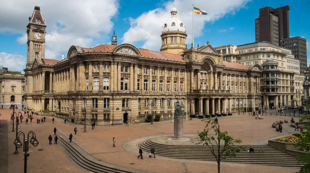
Birmingham Town Hall opened in 1834 and remains one of the city’s most important public buildings. Designed in a monumental classical style inspired by Roman temples, it symbolised civic seriousness and cultural aspiration. It was built as a concert hall and public assembly space, reflecting Birmingham’s strong tradition of public lectures, political meetings, and musical festivals. The building’s style was deliberate. It associated Birmingham, an industrial town without an ancient university or cathedral tradition, with the authority of classical civic culture.
The Council House followed later, built between 1874 and 1879 with later extensions. It served as the headquarters of Birmingham’s municipal government during a period when the city became famous for civic activism, gas and water reform, slum clearance, education policy, and public improvement. Joseph Chamberlain, mayor from 1873 to 1876, became the most famous figure associated with this era. His administration pushed aggressive municipal reform and helped shape Birmingham’s reputation as a model of urban governance.
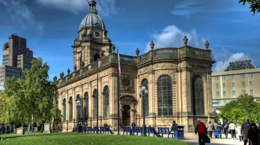
The Council House also housed the Birmingham Museum and Art Gallery, linking municipal administration with public education and art. This arrangement was not accidental. Victorian Birmingham treated museums, libraries, concert halls, and public offices as parts of one civic project. The city aimed to improve urban life not only through engineering and sanitation but also through culture and instruction.
Victoria Square and Chamberlain Square are therefore not just attractive public spaces. They are the physical setting for Birmingham’s transformation into a self-conscious civic capital of the Midlands. The square’s statues, public buildings, and axial views were designed to present authority, order, and permanence.
How does Victoria Square help visitors understand Birmingham’s civic identity?
Victoria Square helps visitors understand Birmingham’s civic identity because it concentrates the city’s major municipal buildings, public art, ceremonial space, and pedestrian routes into one place, making it the clearest expression of Birmingham as a Victorian and modern civic centre.
Victoria Square is often treated as Birmingham’s symbolic centre, and that status is justified by both geography and history. Several of the city’s most important routes meet here. The square sits between the retail spine of New Street, the civic institutions around Chamberlain Square, and the commercial streets running toward Colmore Row and the cathedral quarter.
Its present name honours Queen Victoria, but the square’s deeper significance lies in municipal identity. It fronts the Town Hall and Council House and adjoins the museum quarter. In practical terms, it is the hinge between Birmingham’s commercial and governmental landscapes. In historical terms, it represents the phase when Birmingham used architecture and public space to declare itself a mature city rather than merely a manufacturing town.
Visitors should read the square as a stage set for urban power. Town halls, council offices, museums, and monuments were positioned so that Birmingham’s institutions would appear legible and impressive in one glance. This was especially important in the 19th century, when British industrial cities competed for prestige through architecture, infrastructure, and civic culture.
The square also helps modern visitors navigate efficiently. From here, it is easy to branch south-east toward the Bullring, north-east toward St Philip’s Cathedral, west toward the Library of Birmingham and Centenary Square, or north-west toward the canal corridor and Jewellery Quarter approaches. That makes it both historically central and logistically useful.
Why is St Philip’s Cathedral essential on a Birmingham city centre route?
St Philip’s Cathedral is essential because it marks Birmingham’s early 18th-century expansion beyond the medieval core, preserves one of the city’s most important Georgian landscapes, and anchors the transition from parish market town to a larger commercial and professional centre.
St Philip’s Cathedral began as a parish church rather than a cathedral. Construction started in 1711 and the church was consecrated in 1715 to serve Birmingham’s expanding population, which had outgrown exclusive dependence on St Martin’s. Its creation marks a major turning point in urban history. Birmingham was no longer just the medieval market settlement around the Bull Ring. It was extending northward into a planned Georgian district.
The architect, Thomas Archer, produced one of the most distinguished Baroque churches in England outside London. The building’s tower and restrained classical composition differ sharply from the Gothic idiom of St Martin’s. That contrast is historically useful. It shows that Birmingham’s religious and urban landscape was shaped by different periods, styles, and social needs.
The church became a cathedral only in 1905, when the Diocese of Birmingham was created. By then, the building already carried two centuries of civic and religious significance. It stood amid commercial streets, legal offices, and professional premises, serving a different urban population from the market-centred parish around St Martin’s.
The churchyard remains one of the city centre’s most valuable historic open spaces. In a dense commercial district, it preserves the scale and atmosphere of Georgian Birmingham. Visitors should notice how the cathedral, churchyard, and surrounding streets form a planned composition rather than an accidental survival. This area shows Birmingham’s 18th-century confidence, before the massive Victorian rebuilding that later transformed the rest of the centre.
What do Birmingham’s museums reveal about the city’s history?
Birmingham’s museums reveal that the city’s history cannot be reduced to one industry or one era. They show Birmingham as a place shaped by manufacturing, global trade, scientific innovation, fine art, civic reform, and everyday urban life across several centuries.
A city-centre itinerary becomes much richer when museums are used as interpretive anchors rather than as optional extras. In Birmingham, museums explain the mechanisms behind the buildings and streets that visitors see outdoors.
Birmingham Museum and Art Gallery, historically associated with the Council House complex, represents the Victorian civic belief that art and public education belonged together. Its collections are particularly strong in Pre-Raphaelite art, decorative arts, and local history. For a visitor interested in urban development, the institution matters because it reflects how Birmingham used museum culture to express civic legitimacy. Industrial wealth was converted into permanent public collections and educational resources.
Thinktank, Birmingham’s science museum, serves a different function. Located in Eastside at Millennium Point, it explains the city’s long relationship with invention, engineering, manufacturing, and applied science. Birmingham’s historical identity includes button making, jewellery, metal trades, steam power, transport manufacture, and scientific networks such as the Lunar Society. Thinktank helps visitors connect those economic histories to actual processes and objects rather than to abstract statements about the “workshop of the world”.
The Museum of the Jewellery Quarter, just outside the immediate centre but easy to combine with a longer walking route, is especially valuable for understanding labour and production. It occupies a preserved jewellery workshop and demonstrates how Birmingham’s jewellery trade operated in practice, including design, manufacturing techniques, and workshop organisation. This matters because the Jewellery Quarter was not a decorative side-note to Birmingham’s economy. It was one of the city’s most specialised and internationally significant manufacturing districts.
Together, these museums show that Birmingham’s development involved at least four overlapping systems: trade, craft production, civic culture, and scientific innovation. Seeing at least one museum alongside the outdoor landmarks makes the city easier to interpret accurately.
How do the canals and Brindleyplace fit into Birmingham’s historic story?
The canals and Brindleyplace fit into Birmingham’s historic story because water transport enabled industrial growth, linked workshops to regional and national markets, and created the infrastructure that later allowed regeneration of the city’s west side into a major leisure and cultural district.
Birmingham’s canal network is fundamental to understanding the city. The common public claim that Birmingham has “more canals than Venice” oversimplifies the matter, but the underlying point is correct: canals were central to the city’s industrial rise. In the 18th and 19th centuries they carried coal, metal goods, raw materials, and manufactured products between Birmingham and wider markets. They reduced transport costs and supported dense clusters of workshops, wharves, warehouses, and foundries.
Within the city centre, the canal corridor west of the civic core offers one of the clearest examples of industrial infrastructure adapted for modern use. Walks around the Gas Street Basin and toward Brindleyplace show how former working waterways became part of Birmingham’s post-industrial identity. Bridges, towpaths, basins, and surviving warehouse forms preserve the industrial landscape even where the functions have changed.
This corridor also explains Birmingham’s geography. The westward expansion of the city centre was strongly shaped by canals and later by railway engineering. The city’s planning documents identify canals as integral to the surviving industrial character of the centre, accompanied by wharves, basins, tunnels, and associated industrial remains. ([Birmingham City Council][2])
Brindleyplace itself is modern redevelopment rather than an old district, but it belongs in a historical itinerary because it demonstrates how Birmingham has reused industrial land. Visitors walking from Victoria Square to the Library of Birmingham and then down to the canals can see, in a short distance, the transition from Victorian civic architecture to canal infrastructure and then to late-20th- and early-21st-century regeneration.
Is the Jewellery Quarter close enough to include with Birmingham city centre attractions?
Yes. The Jewellery Quarter is close enough to include if visitors have a full day, because it lies just north-west of the core, is reachable on foot or tram, and preserves one of Europe’s most important historic jewellery manufacturing districts.
The Jewellery Quarter is one of Birmingham’s defining historic landscapes. It developed primarily from the late 18th century onward and became a major centre of jewellery and metalworking production. The district’s significance lies not only in the number of jewellers it contained but also in the survival of its urban fabric: workshops, streets, cemeteries, churches, public buildings, and industrial premises.
For itinerary planning, the question is not whether it is worthwhile. It is. The question is whether to include it in the same day as the Bullring, cathedral, civic core, and canals. In most cases the answer is yes, provided the visitor starts early and chooses a selective route. The walk from the central civic area to the edge of the Quarter is manageable, and tram links reduce the return journey if needed.
Historically, the Quarter shows the industrial side of Birmingham more clearly than the polished central squares do. This was a working district built around specialist production, subcontracting, family firms, and export trade. The concentration of skills helped Birmingham dominate parts of the jewellery market for generations. The area also preserves a different architectural atmosphere from the retail and civic centre. Instead of grand municipal buildings, visitors encounter workshops, terraced commercial premises, institutional buildings, and cemeteries that reflect the social life of an industrial district.
If time is limited, the Museum of the Jewellery Quarter is the most efficient interpretive stop. If time allows, combine it with St Paul’s Square, one of the finest Georgian squares in Birmingham and a useful reminder that industrial prosperity also created residential and ecclesiastical landscapes beyond the old market core.
How can visitors plan the most efficient walking route through Birmingham city centre attractions?
The most efficient walking route is a chronological-westward loop: start at New Street or Moor Street, visit the Bullring and St Martin’s, continue to Victoria Square and Chamberlain Square, move to St Philip’s Cathedral, then head west to the Library and canals, adding the Jewellery Quarter if time permits.
This route works because it reduces backtracking and follows Birmingham’s historical development.
Start at Birmingham New Street if arriving by mainline rail. Walk to the Bullring and St Martin in the Bull Ring first. This covers the medieval market core before crowds build in the shopping district. From there, continue along High Street or New Street toward Victoria Square and Chamberlain Square, where the Town Hall, Council House, and museum quarter explain Victorian Birmingham’s municipal rise.
Next, walk north-east toward St Philip’s Cathedral and its churchyard. This adds the Georgian phase of expansion and provides a quieter contrast to the retail core. From St Philip’s, visitors can decide whether to remain compact or extend the route.
For a compact route, move west toward Centenary Square and the Library of Birmingham, then descend to the canal corridor and Brindleyplace. This creates a full narrative from medieval market town to Georgian church town, Victorian civic metropolis, and regenerated post-industrial centre.
For a full-day heritage route, continue north-west after the canals or from the civic quarter toward the Jewellery Quarter. The tram can simplify the return, but walking also allows visitors to see the shift in urban fabric between the polished central core and the older industrial district.
A practical full-day order looks like this:
- Bullring and St Martin’s
- Markets and surrounding medieval street pattern
- Victoria Square and Chamberlain Square
- Town Hall and Council House exterior study
- St Philip’s Cathedral and churchyard
- Lunch around Colmore Row, Paradise, or the canal district
- Library of Birmingham and Centenary Square
- Canal walk to Brindleyplace or Gas Street Basin
- Optional Jewellery Quarter extension
This route is efficient because each segment connects directly to the next, and each segment represents a clear stage in Birmingham’s development.
Why do Birmingham city centre attractions matter beyond tourism?
Birmingham city centre attractions matter beyond tourism because they preserve evidence of urban planning, industrialisation, municipal reform, religious history, transport change, and heritage conservation, making them valuable to researchers, educators, and residents as well as visitors.
Historic attractions are often treated as leisure assets only. In Birmingham, they are also records of how a major British city was made. St Martin’s preserves the logic of the medieval market town. St Philip’s marks 18th-century population growth and planned expansion. The Town Hall and Council House record the ambitions of Victorian municipal government. The canals reveal industrial logistics. The Jewellery Quarter documents specialised manufacturing and labour history. Modern redevelopment zones show how post-industrial cities adapt inherited landscapes.
For educators, this concentration is especially useful. Birmingham city centre offers case studies in medieval borough formation, Georgian church building, Victorian civic culture, industrial transport, retail redevelopment, and conservation planning within a single walkable area. For local historians and genealogical researchers, the same landscape provides context for parish records, trade directories, workshop histories, burial grounds, and property development patterns. For preservationists, it offers visible evidence of what survives, what has been adapted, and what has been lost.
The city’s own planning and heritage frameworks emphasise this continuity. They identify surviving street patterns, canal corridors, archaeological remains, listed buildings, and conservation areas as part of Birmingham’s historic environment and long-term identity. In other words, the attractions near Birmingham city centre are not isolated monuments. They are pieces of a still legible urban system. ([Birmingham City Council][2])
Birmingham city centre is one of the most efficient urban heritage areas in England because its attractions can be read as a continuous historical sequence. The route begins in the medieval market landscape of the Bullring and St Martin’s, expands through the Georgian order of St Philip’s, reaches the Victorian civic confidence of Victoria Square and the Council House, and then extends into the canal and industrial landscapes that powered Birmingham’s growth. A longer day adds the Jewellery Quarter, where specialist manufacturing shaped the city’s international reputation.
For visitors, the practical lesson is simple: Birmingham works best when it is explored as a connected historical system rather than as a list of disconnected sights. The city centre’s attractions are close enough to combine, varied enough to reward a full day, and historically rich enough to explain how Birmingham moved from planned market town to industrial giant and modern cultural capital. That combination makes it one of the strongest city-centre heritage itineraries in the Midlands and one of the most accessible introductions to Birmingham’s long urban history.
What are the best attractions near Birmingham city centre?
The best attractions near Birmingham city centre include Bullring, St Martin in the Bull Ring, Victoria Square, Birmingham Town Hall, St Philip’s Cathedral, Library of Birmingham, the Birmingham canal network, and the Jewellery Quarter.