Birmingham’s canals form one of the most important surviving landscapes of Britain’s Industrial Revolution. The city contains around 35 miles of canals within its administrative area, while the wider Birmingham Canal Navigations (BCN) network extends for more than 100 miles today. The waterways connect historic industrial districts, modern cultural quarters, public spaces, bridges, locks and regenerated waterfronts.
- What makes Birmingham’s canals historically important?
- When did Birmingham’s canal network develop?
- How did the canals transform Birmingham during the Industrial Revolution?
- Which canal walk best introduces Birmingham’s industrial heritage?
- What can visitors see around Gas Street Basin?
- Why is the Birmingham & Fazeley Canal important for walking?
- What historical attractions are located beside Birmingham’s waterways?
- How did Birmingham’s canals change after railways and roads became dominant?
- Which longer canal routes connect Birmingham’s history with its wider landscape?
- How are Birmingham’s canals being preserved for future generations?
- Why do Birmingham’s canal walks remain historically significant today?
- Frequently Asked Question
The canal system transformed Birmingham during the eighteenth and nineteenth centuries. It reduced the cost of transporting coal, iron, raw materials and manufactured goods and connected the rapidly expanding town with national markets. Today, the same waterways provide walking routes through the city centre and preserve physical evidence of industrial development.
The most accessible historic walks include the route from Livery Street to the Mailbox, the Gas Street Basin and Brindleyplace waterfront, the Birmingham & Fazeley Canal toward Farmer’s Bridge Locks, and longer towpath routes along the Worcester & Birmingham Canal. Each route reveals a different stage of Birmingham’s urban history.
For history enthusiasts, these walks are outdoor heritage corridors. For educators and students, they provide direct evidence of industrial infrastructure, transport technology, urban redevelopment and conservation. For cultural visitors, they connect museums, galleries, theatres, restaurants and public spaces with surviving canal structures.
What makes Birmingham’s canals historically important?
Birmingham’s canals are historically important because they powered industrial expansion, connected factories with national markets, transported coal and metals, and created the infrastructure that helped transform Birmingham into a major manufacturing and commercial centre during Britain’s Industrial Revolution.
The first Birmingham Canal Navigation developed from a local attempt to improve transport connections with the Staffordshire and Worcestershire Canal. Local interests proposed the project in 1767, James Brindley surveyed the route, and Parliament passed the necessary Act in 1768. The first section between Wednesbury and Birmingham was completed in 1769.
James Brindley was an eighteenth-century canal engineer and millwright. He became one of the principal figures in Britain’s early canal-building period. His work on the Birmingham Canal established an important transport connection between Birmingham and the Black Country.
The Birmingham Canal Main Line was subsequently extended towards Wolverhampton. The wider system developed through successive branches and connections, eventually creating the Birmingham Canal Navigations. Birmingham City Council records that the BCN reached more than 170 miles at its historical peak.
The canals were built primarily for commercial transport rather than recreation. Coal was particularly important because Birmingham’s industries required large quantities of fuel. Iron, building materials and manufactured goods also moved through the network.
The transport system changed the economics of industrial production. Water transport allowed heavy materials to move more efficiently than existing road transport. Birmingham’s location within a dense network of waterways therefore became an important factor in its industrial expansion.
The canal landscape still preserves this history through towpaths, bridges, locks, warehouses, wharves, junctions, aqueducts and surviving industrial buildings.
When did Birmingham’s canal network develop?
Birmingham’s canal network developed mainly between 1768 and the nineteenth century, beginning with the Birmingham Canal and expanding through connections such as the Worcester & Birmingham Canal, Birmingham & Fazeley Canal, Stratford-upon-Avon Canal and later engineering works by Thomas Telford.
The key starting point came in 1768 when the Birmingham Canal Navigation company received parliamentary authority. Brindley and his assistants Robert Whitworth and Samuel Simcock completed the first section between Wednesbury and Birmingham in 1769.
The canal subsequently reached towards Wolverhampton. The system expanded through new routes, branches and junctions as Birmingham’s industrial requirements increased.
The Worcester & Birmingham Canal received its Act in 1791. Its purpose was to create a shorter water connection between Birmingham and the River Severn. Construction began at Birmingham, but financial and engineering difficulties slowed progress. The entire route opened in 1815.
The Birmingham & Fazeley Canal created another important connection from the city centre towards the wider Midlands network. Its modern route begins at Gas Street Basin and passes through the Farmer’s Bridge Locks before continuing towards the wider canal system.
The early canal network also faced major water-management problems. Canals depended on controlled water levels, reservoirs, feeders and locks. Different canal companies protected their water supplies and charged tolls for the use of their infrastructure.
The conflict between the Birmingham Canal and Worcester & Birmingham Canal is particularly visible at Worcester Bar. The barrier separated the two waterways and required goods to be transferred between boats until a stop lock eventually connected the routes in 1815.
The network continued to evolve during the nineteenth century. Thomas Telford became involved with Birmingham’s canals in the 1820s and proposed improvements to sections that had become inefficient. His later New Main Line shortened and straightened the earlier Birmingham Canal route.
How did the canals transform Birmingham during the Industrial Revolution?
The canals transformed Birmingham by creating cheaper and more reliable routes for heavy goods, supporting coal-fired industry, connecting manufacturers with regional markets, and concentrating factories, warehouses, wharves and workshops around navigable waterways.
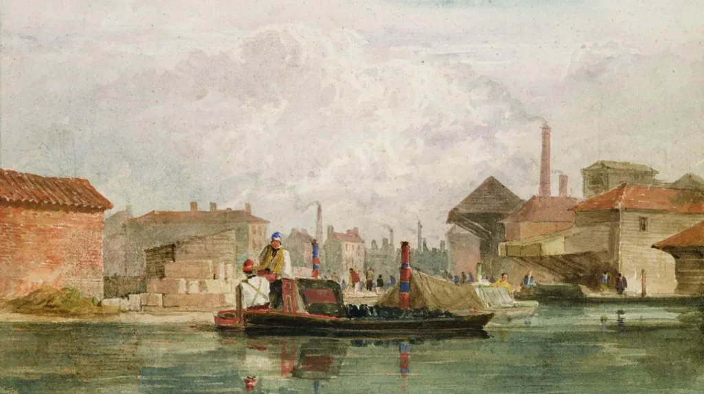
Before canal construction, Birmingham depended heavily on roads for the movement of goods. Heavy materials were expensive to transport over poor eighteenth-century roads. Canal transport addressed this problem by providing navigable routes for large quantities of bulk materials.
Coal became one of the most important canal commodities. Birmingham’s manufacturing industries required fuel for furnaces, forges and other industrial processes. The canal network connected the city with coal-producing areas in the Black Country and beyond.
The relationship between industry and waterways shaped the urban landscape. Factories and warehouses were frequently positioned beside canals or canal arms. Wharves provided loading and unloading areas, while bridges and towpaths supported movement around industrial sites.
Gas Street Basin provides one of the clearest surviving examples of this relationship. The basin became a major meeting point between Birmingham’s waterways and developed as an industrial transport area. Historic maps held by Birmingham’s archives record canal sections, the Bar Lock and industrial properties around Gas Street and Bridge Street during the nineteenth century.
The scale of canal commerce was substantial. Birmingham City Council records that the BCN carried approximately 8.5 million tonnes of goods in 1898, demonstrating the scale of commercial activity reached by the network at the end of the nineteenth century.
The canals also supported Birmingham’s specialist manufacturing industries. The Jewellery Quarter, for example, developed as a concentrated metalworking district close to transport infrastructure and the city’s Assay Office. English Heritage records Birmingham’s development as a major metalworking centre and notes that more than 70,000 people were employed in the city’s metalworking sector in the early twentieth century.
The waterways therefore represent more than transport history. They document the interaction between engineering, manufacturing, labour, commerce and urban expansion.
Which canal walk best introduces Birmingham’s industrial heritage?
The Livery Street to Mailbox canal walk provides the clearest introduction to Birmingham’s central canal heritage because its approximately one-mile route passes Farmer’s Bridge Locks, Old Turn Junction, Brindleyplace, Gas Street Basin, Worcester Bar and the regenerated Mailbox waterfront.
The Canal & River Trust identifies the Livery Street to Mailbox route as approximately 1.6 kilometres. It begins at Livery Street Bridge and ends at the Mailbox, passing several of the city centre’s most significant canal features.
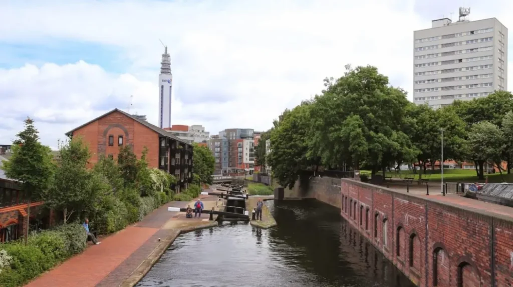
Farmer’s Bridge Locks demonstrate how canal engineers managed changes in elevation. A lock is a chamber that raises or lowers boats between different water levels. Lock flights allowed Birmingham’s waterways to overcome the city’s uneven topography while maintaining navigable routes.
The route then approaches Old Turn Junction and Brindleyplace. The junction is historically important because it demonstrates the dense connectivity that made Birmingham’s canal system distinctive.
Brindleyplace occupies a regenerated waterfront area that previously contained Victorian workshops, warehouses, factories and canal-connected wharves. The modern development retains the canal as the organising feature of the public realm.
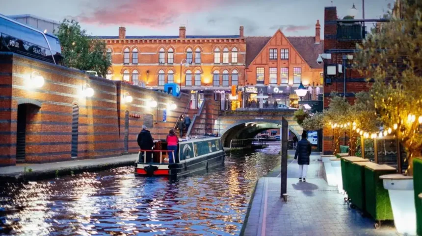
The walk continues towards Gas Street Basin. This is one of Birmingham’s most recognisable canal locations because historic industrial structures stand alongside modern buildings and active waterfront businesses.
Gas Street Basin also demonstrates the transition from industrial transport to leisure infrastructure. Historic Birmingham canals once carried commercial cargo, while the modern basin primarily supports leisure boating, tourism, walking and waterfront activity. Historic England records this transformation in its archive material on the basin.
The route then reaches Worcester Bar, where the history of competing canal companies becomes visible in the physical landscape. The surviving barrier records the commercial disputes that once surrounded water supply and canal tolls.
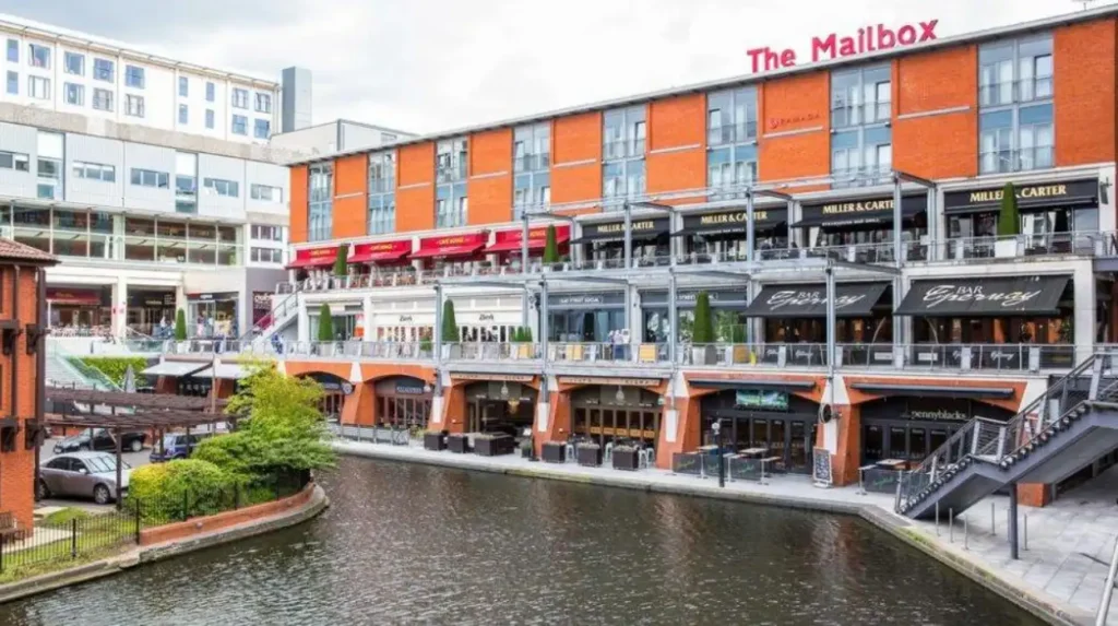
The walk finishes near the Mailbox, a former Royal Mail sorting-office complex that has been incorporated into Birmingham’s modern commercial and cultural waterfront. The contrast between industrial waterways and contemporary architecture makes this route particularly useful for understanding urban regeneration.
To experience this historic canal landscape in person today, consult our comprehensive [How to Explore Birmingham’s Canals and Waterfront Areas] for itineraries and visiting parameters.
What can visitors see around Gas Street Basin?
Gas Street Basin combines historic canal infrastructure, surviving industrial buildings, bridges, towpaths and modern waterfront development. Its principal heritage features include Worcester Bar, canal junctions, historic walls, the Holliday Street Canal Aqueduct and restored industrial structures.
Gas Street Basin stands at the centre of Birmingham’s canal network. The Canal & River Trust describes it as a key meeting point where the city’s historic waterways meet modern waterfront development.
The basin is particularly important because several layers of Birmingham’s history remain visible within a small area. Historic canal routes, industrial buildings and nineteenth-century infrastructure sit beside modern offices, restaurants and public spaces.
The Worcester Bar is one of the most important surviving structures. The barrier separated the Worcester & Birmingham Canal from the Birmingham Canal system. The Canal & River Trust records that the bar was built in 1792 and that a stop lock eventually allowed boats to pass between the waterways in 1815.
The history of the bar demonstrates how private canal companies operated. Each company controlled its own waterway and sought to protect water supplies and revenue from tolls.
Another important structure is the Holliday Street Canal Aqueduct. Historic England dates the existing aqueduct to 1870. It carries the canal over Holliday Street using cast-iron structural elements, brick vaulting and decorated cast-iron columns. It is listed at Grade II for its special architectural and historic interest.
The surrounding walls and canal access points also contain historic evidence. Historic England records an early nineteenth-century Grade II-listed wall and ramps leading from Gas Street towards the canal.
These structures show that canal heritage is not limited to the water itself. Engineering components above and beside the water reveal how the system functioned.
The basin also provides access to modern cultural and leisure destinations around Brindleyplace, Broad Street, the National SEA LIFE Centre, Symphony Hall and the wider city centre. The resulting waterfront combines industrial archaeology with contemporary urban use.
Why is the Birmingham & Fazeley Canal important for walking?
The Birmingham & Fazeley Canal provides a historic walking route from Gas Street Basin through central Birmingham, including Farmer’s Bridge Locks, tunnels, bridges and towpaths before continuing towards the wider Midlands canal landscape.
The Birmingham & Fazeley Canal begins at Gas Street Basin and forms a direct connection between the central city and the wider canal network. Its towpath provides a route through a landscape that changed significantly during the twentieth century.
During the industrial period, sections of the canal were enclosed behind walls and surrounded by industrial premises. The canal therefore operated as a working transport corridor rather than an open recreational landscape.
Later regeneration changed its function. During the 1980s, sections were reopened and towpaths were resurfaced to improve access for walkers and cyclists.
Farmer’s Bridge Locks are among the most significant features on this route. The flight demonstrates the engineering required to move boats through changing elevations within a dense urban environment.
The canal also passes beneath bridges and through enclosed sections. These features provide physical evidence of the relationship between nineteenth-century transport engineering and later urban construction.
The route eventually connects with larger canal corridors outside the central city. This makes the Birmingham & Fazeley Canal useful for understanding the BCN as a network rather than a collection of isolated waterways.
The Canal & River Trust identifies the wider Birmingham ring as a route linking Gas Street Basin and Brindleyplace with the Old Main Line, Smethwick Locks, Aston Locks, Farmer’s Bridge Locks and other parts of the historic network.
For walkers interested in engineering history, locks and junctions provide some of the strongest physical evidence of how Birmingham’s canal system operated.
What historical attractions are located beside Birmingham’s waterways?
Birmingham’s canal-side attractions include Brindleyplace, the National SEA LIFE Centre, Birmingham Rep, Gas Street Basin, the Mailbox, historic canal structures, industrial buildings and cultural venues that demonstrate the city’s transition from manufacturing centre to modern waterfront destination.
Brindleyplace is one of the most prominent examples of canal-led regeneration. Its name commemorates James Brindley, the engineer associated with Birmingham’s first canal development. The modern estate incorporates public squares, commercial buildings and cultural facilities around the historic canal environment.
The National SEA LIFE Centre occupies a prominent position beside the canal at Brindleyplace. Its location demonstrates how the former industrial waterfront has become part of Birmingham’s visitor economy.
The Birmingham Repertory Theatre, commonly known as Birmingham Rep, is another major cultural institution within the central waterfront area. The theatre forms part of the cultural environment surrounding Brindleyplace and Centenary Square.
The Mailbox provides a different example of adaptive urban development. The complex developed from a former Royal Mail sorting-office site and now contains commercial, hospitality and media-related uses. The Canal & River Trust identifies it as the endpoint of the Livery Street to Mailbox canal walk.
The canals also provide access to public spaces and pedestrian routes that connect different parts of the city centre. This makes the waterways useful for visitors studying the relationship between historic infrastructure and contemporary urban planning.
The importance of these attractions is not simply their proximity to water. Their locations reflect the transformation of land that was historically occupied by factories, warehouses, wharves and transport infrastructure.
The waterfront therefore provides a continuous historical sequence. Industrial canal construction came first. Commercial canal transport followed. Decline in heavy waterborne freight came later. Regeneration then transformed selected canal corridors into cultural, residential, commercial and recreational spaces.
How did Birmingham’s canals change after railways and roads became dominant?
Birmingham’s canals declined as railways and roads became more efficient for many forms of freight transport, but the network survived through engineering adaptations, heritage conservation, towpath improvements and conversion from commercial waterways into recreational and urban regeneration assets.
Railways changed British transport during the nineteenth century by providing faster long-distance freight and passenger services. Roads later became increasingly important as motor transport expanded.
The canals did not immediately disappear. Commercial traffic remained significant for decades because waterways continued to transport heavy and bulky materials. Birmingham City Council records approximately 8.5 million tonnes of goods carried by the BCN in 1898.
The twentieth century brought a sustained decline in traditional canal freight. Commercial activity reduced as road haulage and other transport systems became more competitive.
By 1980, commercial traffic on Birmingham’s canals had stopped, according to Birmingham City Council. Many sections subsequently suffered from neglect and deterioration.
The change in use produced a new phase of canal history. Instead of functioning primarily as industrial transport corridors, the waterways became heritage and recreational assets.
Towpaths were improved for walking and cycling. Former industrial buildings were restored or incorporated into new developments. Waterfront areas around Gas Street Basin and Brindleyplace became important parts of Birmingham’s visitor economy.
Historic England’s archive records this broader transition, noting that canals once vital to Birmingham’s industry are now mainly used by pleasure boats, while many towpaths function as cycle routes.
This transformation demonstrates the long-term adaptability of Birmingham’s industrial heritage. The physical infrastructure survived even when its original economic purpose disappeared.
Which longer canal routes connect Birmingham’s history with its wider landscape?
Longer Birmingham canal routes connect the city centre with historic industrial districts, suburbs, reservoirs, locks and neighbouring waterways. Important examples include the Old Main Line, New Main Line, Birmingham & Fazeley Canal, Worcester & Birmingham Canal and the wider Birmingham Canal Navigations ring.
The New Main Line is one of the most important examples of nineteenth-century canal engineering. Thomas Telford designed it to shorten and straighten the earlier Birmingham Canal Old Main Line. The route is approximately 8.4 miles long.
The engineering objective was practical. A straighter route reduced journey distances and removed locks from the main line, improving the efficiency of commercial navigation.
The Old Main Line survives as an important historic waterway. Sections of the original route demonstrate how canal engineers adapted routes as traffic volumes and commercial requirements changed.
The Birmingham & Fazeley Canal provides another major route from the city centre. It passes Farmer’s Bridge Locks and continues towards the wider Midlands network.
The Worcester & Birmingham Canal provides a southern connection from Birmingham towards Worcester and the River Severn. Its construction reflects the importance of creating direct links between industrial Birmingham and major river systems. The route opened throughout in 1815.
The wider Birmingham ring includes several technically important locations. The Canal & River Trust identifies Aston Locks, Farmer’s Bridge Locks, Smethwick Locks, the Old Main Line and other interconnected waterways as part of the broader cruising route.
These longer routes are particularly valuable for historical study because they reveal the relationship between Birmingham and the Black Country. The canals were designed as interconnected infrastructure, so their historical significance extends beyond the city-centre waterfront.
A longer towpath journey also reveals changing land use. Industrial buildings give way to housing, parks, roads, rail infrastructure and open landscapes. The canal remains the continuous historical feature linking these environments.
How are Birmingham’s canals being preserved for future generations?
Birmingham’s canals are preserved through listed structures, conservation policies, towpath maintenance, heritage interpretation, regeneration projects and continued use as navigable waterways, ensuring that locks, bridges, aqueducts, basins and industrial landscapes remain part of the city’s historic environment.
Canal preservation involves both physical structures and the wider landscape. Historic bridges, aqueducts, walls and canal-side buildings provide tangible evidence of past engineering and industry.
The Holliday Street Canal Aqueduct demonstrates formal statutory protection. Historic England lists the structure at Grade II because of its architectural and historic significance.
Gas Street Basin provides another preservation example. Historic canal structures have survived alongside modern waterfront development, allowing visitors to observe the relationship between industrial archaeology and contemporary regeneration.
Birmingham City Council identifies the canal network as an important part of the city’s industrial heritage and notes the transformation of canal surroundings through restoration, parkland, housing, shops, restaurants and entertainment uses.
The Canal & River Trust manages and maintains navigable waterways across Birmingham. Its city-centre information identifies Gas Street Basin and Brindleyplace as important parts of the Birmingham boating ring and provides access information for visitors.
Walking itself contributes to heritage visibility. Towpaths create public access to infrastructure that was historically associated with industrial transport and restricted working environments.
The Platinum Jubilee Walkway provides another modern interpretation of Birmingham’s history. The 22-kilometre circular route contains 20 points of significance, with almost half of the route following Birmingham’s canals. It connects Farmer’s Bridge Locks, Brindleyplace, Gas Street, the Mailbox and the Worcester & Birmingham Canal with other city landmarks.
For educators, these routes provide a practical framework for examining industrialisation, engineering, transport, architecture and urban regeneration. For heritage researchers, surviving canal structures provide physical evidence that complements maps, company records and municipal archives.
Why do Birmingham’s canal walks remain historically significant today?
Birmingham’s canal walks remain historically significant because they preserve the physical infrastructure of industrial transport while connecting modern cultural districts, public spaces and regenerated waterfronts with the engineering and commercial history that shaped the city.
The canals represent a continuous historical landscape rather than a single monument. Their importance comes from the interaction of water, engineering, industry, transport, architecture and urban development.
Gas Street Basin demonstrates this continuity particularly clearly. Historic canal companies once competed for water and toll revenue in the area. Today, the basin functions as a major public waterfront and visitor destination.
Brindleyplace demonstrates the next stage of the story. Former industrial land and canal-connected premises became a modern commercial and cultural district while retaining the waterway as a central feature.
The Farmer’s Bridge Locks preserve evidence of eighteenth- and nineteenth-century canal engineering. The New Main Line records the later rationalisation of the network under Telford. The Worcester Bar records commercial competition between canal companies. The Holliday Street Aqueduct records nineteenth-century cast-iron engineering.
Together, these structures provide a physical chronology of Birmingham’s development.
The network also has continuing educational value. Students can observe how transport infrastructure influenced industrial location, how engineering responded to geography, and how cities reuse historic infrastructure after economic conditions change.
For genealogical researchers, canal districts provide another dimension to Birmingham’s urban history. Industrial neighbourhoods, manufacturing districts and transport corridors shaped where workers lived and where businesses operated. Municipal maps and canal-company records can therefore complement family-history research.
Birmingham’s canal walks are consequently more than leisure routes. They are accessible heritage corridors that preserve evidence of the city’s industrial transformation and its continuing adaptation to new economic and cultural uses.
The surviving network also demonstrates why industrial heritage requires landscape-scale conservation. Individual bridges, locks or warehouses provide limited historical information when isolated. Their meaning becomes clearer when they are understood as components of a connected transport system.
Birmingham’s canals therefore remain relevant to the city’s historical identity. They document the engineering decisions, commercial relationships and industrial activity that helped build modern Birmingham while continuing to function as public spaces within the contemporary city.
The strongest canal walks begin in the city centre but extend beyond individual attractions. A walk from Livery Street through Farmer’s Bridge, Brindleyplace, Gas Street Basin and the Mailbox provides a compact introduction. Longer journeys along the Birmingham & Fazeley Canal, Old Main Line, New Main Line and Worcester & Birmingham Canal reveal the larger system.
This combination of surviving infrastructure and modern public access makes Birmingham one of Britain’s most important urban canal landscapes. The waterways remain visible evidence of the Industrial Revolution and an enduring part of Birmingham’s architectural, cultural and environmental heritage.
Frequently Asked Question
What is the best canal walk in Birmingham?
The Livery Street to Mailbox canal walk is one of the best introductions to Birmingham’s waterways. The route covers about 1.6 kilometres and passes Farmer’s Bridge Locks, Old Turn Junction, Brindleyplace, Gas Street Basin and Worcester Bar.