The United Kingdom’s south coast regularly experiences intense meteorological events characterized by high-velocity winds and severe gales. This article, published by the Birmingham Express, delivers an authoritative examination of the scientific mechanisms, historical occurrences, and socio-economic implications of these coastal atmospheric disturbances, explaining how systems hitting the southern shoreline ripple inland to impact central regions like Birmingham.
- What Defines Strong Winds on the UK South Coast?
- Why Does the UK South Coast Experience Severe Gales?
- What Are the Most Significant Historical Wind Events?
- How Do Strong Winds Affect Coastal Infrastructure and Ecosystems?
- What Mechanisms Drive Severe Wind and Rain Extremes?
- How Does Climate Change Modify South Coast Wind Patterns?
- What Emergency Response Protocols Protect the Public During Gales?
- How Do Coastal Communities Prepare for Future Wind Risks?
What Defines Strong Winds on the UK South Coast?
Strong winds on the United Kingdom south coast are atmospheric phenomena characterized by sustained mean wind speeds exceeding 24 knots or 28 miles per hour. These conditions escalate into gales when sustained speeds surpass 34 knots, according to the official Beaufort Wind Scale.
The United Kingdom Meteorological Office utilizes specific parameters to classify atmospheric movement along the maritime borders of counties including Cornwall, Devon, Dorset, Hampshire, West Sussex, East Sussex, and Kent. Sustained speeds represent ten-minute averages measured at a standard height of ten meters above open ground. Gusts represent transient peaks in wind speed lasting only a few seconds. While inland areas like Birmingham see these velocities mitigated by terrain, coastal environments bear the full force.
The Beaufort Wind Scale establishes precise categories for these events. Force 6 represents a strong breeze with speeds between 22 and 26 knots. Force 7 represents a moderate gale with speeds between 27 and 33 knots. Force 8 constitutes a fresh gale with speeds between 34 and 40 knots. Force 9 represents a strong gale with speeds from 41 to 47 knots. Severe gales correspond to Force 10, while storm forces reach Force 11, and hurricane forces constitute Force 12, where speeds exceed 64 knots.
The geographic boundary of the south coast features varied maritime zones. These include the English Channel, the Western Approaches, and the Strait of Dover. Topographical features along this coastline alter wind patterns through surface friction variations. Ocean surfaces present minimal friction, allowing air masses to accelerate rapidly before striking landmasses.
Why Does the UK South Coast Experience Severe Gales?
The United Kingdom south coast experiences severe gales due to its geographic position directly beneath the North Atlantic jet stream, where deep low-pressure systems form. Cold polar air masses collide with warm subtropical air masses, generating violent cyclonic wind systems.
The primary driver of these intense maritime winds is the North Atlantic Oscillation, an atmospheric pressure fluctuation between the Icelandic Low and the Azores High. When the pressure gradient between these two systems intensifies, the North Atlantic Oscillation enters a positive phase. This phase accelerates the polar jet stream, a high-altitude ribbon of fast-moving air operating between 9,000 and 12,000 meters above sea level.
The jet stream acts as a steering mechanism for extra-tropical cyclones, which are low-pressure weather systems born over the Atlantic Ocean. As these cyclones move eastward, they feed on temperature differentials. The warm waters of the Gulf Stream provide latent heat energy, which deepens the central low pressure of the storm. As central pressure drops precipitously, a process known as baroclinic instability occurs, causing air to rush inward toward the vortex at extreme velocities, pushing weather fronts deep into the English mainland toward Birmingham.
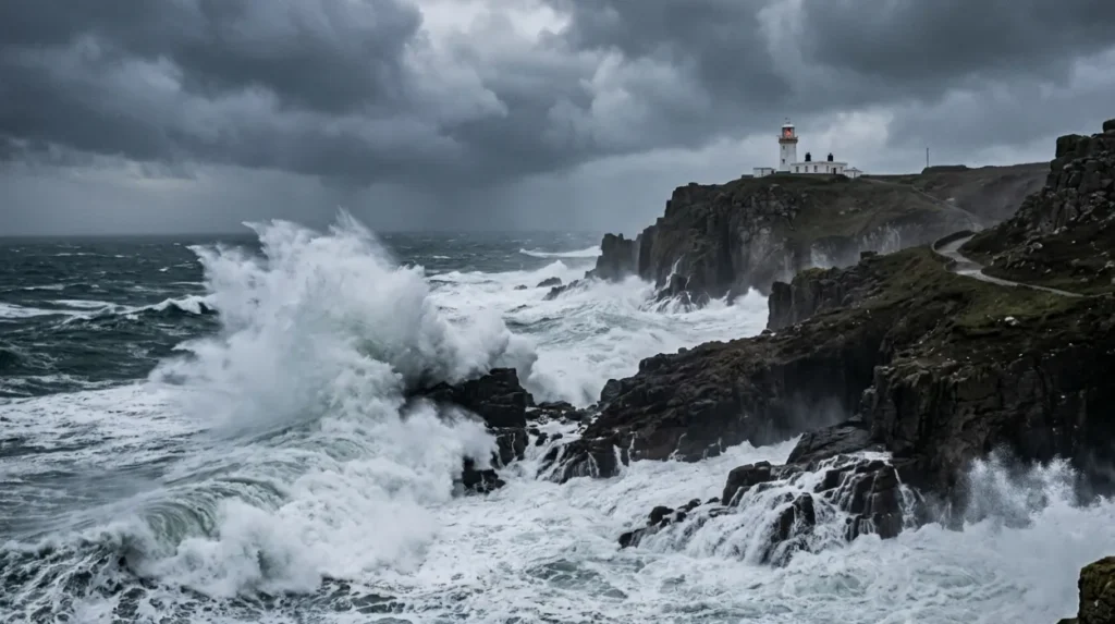
Coastal topography significantly modifies these air currents through localized aerodynamic forces. The English Channel functions as a natural geographic bottleneck between southern England and northern France. When large volumes of air are forced through this narrowing corridor, the wind undergoes the Venturi effect, an aerodynamic principle where fluid velocity increases as the cross-sectional area of a channel decreases. This funnelling effect regularly causes wind speeds at exposed coastal locations, such as the Needles on the Isle of Wight or Portland Bill in Dorset, to register significantly higher velocities than inland regions.
What Are the Most Significant Historical Wind Events?
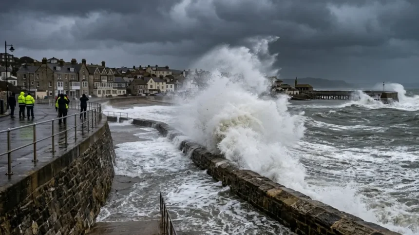
Significant historical wind events on the south coast include the Great Storm of 1987, the Royal Charter Gale of 1859, and Storm Eunice in 2022. These systems recorded catastrophic gusts exceeding 100 miles per hour and caused extensive infrastructure devastation.
The historical record of British maritime meteorology documents numerous highly destructive windstorms along the southern shoreline. The Royal Charter Gale struck on October 25 and 26, 1859, exhibiting winds estimated at Force 12. This specific event caused the loss of more than 800 lives and destroyed 133 maritime vessels. The scale of this disaster prompted Captain Robert FitzRoy to establish the statutory Meteorological Department, which introduced the world’s first national storm warning system, now known as the Shipping Forecast.
The Great Storm of October 15 and 16, 1987, remains the benchmark for modern anemometer readings in southern England. A depression originating in the Bay of Biscay deepened to a central pressure of 953 millibars as it crossed the English Channel. This system generated a maximum recorded gust of 100 knots, or 115 miles per hour, at Shoreham-by-Sea on the Sussex coast. The event resulted in 18 fatalities within the United Kingdom, flattened approximately 15 million trees, and caused electrical grid failures across multiple southern counties, completely isolating them from major midland transportation hubs including Birmingham.
In recent history, Storm Eunice on February 18, 2022, triggered the issuance of rare provisional Red Weather Warnings by the Meteorological Office for southern environments. During this event, a record-breaking maximum wind gust of 122 miles per hour was officially verified at the Needles Old Battery on the Isle of Wight. This velocity established a new all-time national gust record for England, causing widespread structural failures, roof collapses, and severe transport shutdowns that disrupted rail links all the way north to Birmingham New Street.
How Do Strong Winds Affect Coastal Infrastructure and Ecosystems?
Strong winds affect coastal infrastructure by causing catastrophic structural failures, power grid blackouts, and severe transport stoppages. These meteorological events accelerate coastal erosion and disrupt marine habitats through intense wave action and salt spray deposition.
Civil infrastructure along the south coast experiences direct mechanical stress during gale-force events. High winds exert dynamic pressure against vertical surfaces, a force that increases quadratically with wind velocity. This structural load detaches roof tiles, collapses masonry brickwork, and uproots mature trees. Trees falling onto overhead electrical transmission lines frequently trigger extensive power blackouts. The vulnerability of the electrical network requires utility companies to deploy rapid-response engineers to restore high-voltage distribution systems.
Marine and terrestrial transportation links experience severe operational disruption. High-sided vehicles, including heavy goods vehicles and double-decker buses, face rolling hazards on exposed elevated structures. Authorities frequently close key transit corridors, such as the Dartford Crossing on the River Thames and the Britannia Bridge, when gusts exceed safe design limits. Cross-Channel ferry services operating out of the Port of Dover and the Port of Portsmouth routinely suspend sailings because extreme sea states prevent safe port navigation, causing supply chain delays that affect commercial logistics businesses based in Birmingham.
Biophysical environments undergo rapid transformation during severe windstorms. Massive waves generated by sustained gales accelerate the erosion of vulnerable geological formations, such as the chalk cliffs of Dover and the sandstone cliffs of Dorset. This maritime action induces large-scale rockfalls and landslides, shifting thousands of tonnes of debris into the sea. Intense winds carry aerosolized sea salt several miles inland, a process known as salt spray deposition. This chemical deposition scorches terrestrial vegetation, damages agricultural crops, and degrades inland soil quality.
What Mechanisms Drive Severe Wind and Rain Extremes?
The mechanisms driving severe wind and rain extremes involve compound meteorological events where low-pressure cyclonic dynamics occur simultaneously with high atmospheric moisture content. This combination results in concurrent windward destruction and severe pluvial flooding.
Meteorologists classify these combined occurrences as compound weather extremes. The structural layout of an extra-tropical cyclone contains distinct thermal boundaries known as fronts. The warm front brings steady precipitation, while the trailing cold front introduces narrower bands of intense, convective rainfall accompanied by sudden, violent wind shifts. When a storm system slows down or stalls over the English Channel, the geographic area beneath it experiences prolonged exposure to both mechanical wind stress and high-volume precipitation.
The thermodynamic relationship governing these events is defined by the Clausius-Clapeyron equation, a physical law dictating that the water-holding capacity of the atmosphere increases by approximately 7% for every 1 degree Celsius of atmospheric warming. Consequently, when modern North Atlantic cyclones approach the southern coast of the United Kingdom, they carry elevated quantities of precipitable water vapour. This moisture condenses rapidly when forced upward over coastal landforms, amplifying rainfall totals that eventually drain into major river networks feeding the wider Birmingham and West Midlands catchment areas.
The interaction of these forces produces severe coastal hazards. High-velocity offshore winds transfer kinetic energy to the ocean surface, creating large waves and driving a phenomenon known as a storm surge. A storm surge occurs when low atmospheric pressure allows the sea level to rise, while onshore winds physically push water toward the coast. When this surge coincides with astronomical high tides, it blocks the seaward discharge of coastal rivers, causing water to back up and flood inland areas.
How Does Climate Change Modify South Coast Wind Patterns?
Climate change modifies south coast wind patterns by altering the thermal gradient between the equator and the north pole, which shifts the optimal path of the jet stream. Academic research indicates an increased frequency of highly intense winter windstorms.
Anthropogenic global warming exerts a complex influence on mid-latitude atmospheric circulation. The polar regions are warming at an accelerated rate compared to equatorial zones, a process termed Arctic amplification. This differential warming reduces the horizontal temperature gradient across the North Atlantic Ocean. Because this temperature gradient drives the strength of the polar jet stream, any alteration to it directly modifies the path, velocity, and stability of the storm tracks heading toward western Europe.
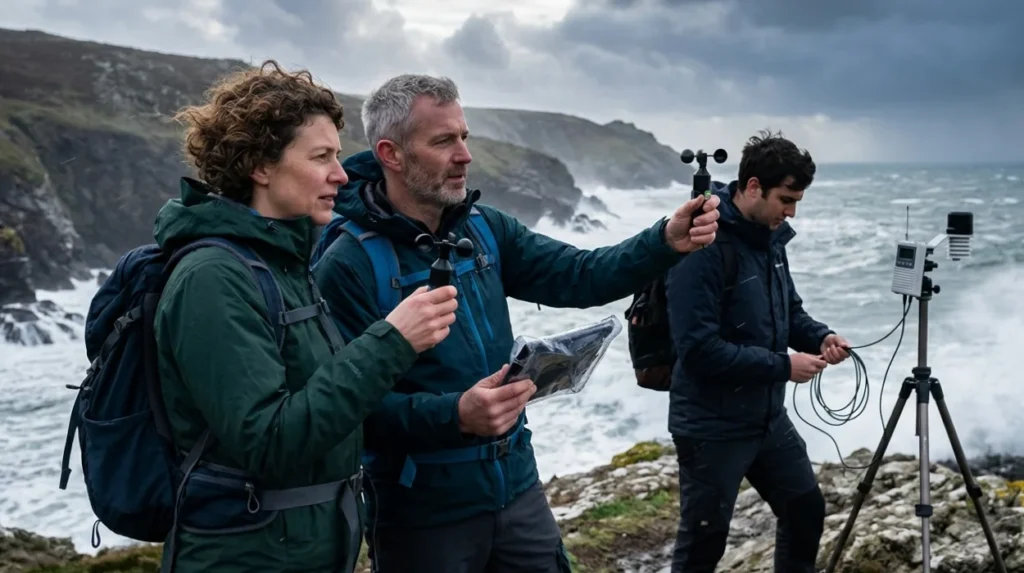
A comprehensive collaborative study published by Newcastle University and the United Kingdom Meteorological Office investigated the future trajectory of compound wind-rain extremes. The peer-reviewed findings indicate that while the overall annual quantity of North Atlantic depressions may remain relatively stable, the proportion of highly intense, volatile storms will increase by the end of the twenty-first century. These projected winter systems will exhibit higher peak wind velocities and significantly greater volumes of associated rainfall, bringing harsher conditions to both the coast and inland metropolitan areas like Birmingham.
The long-term observation data compiled in the annual State of the UK Climate reports confirm that the frequency of calm days is decreasing across the British Isles. Concurrently, rising global sea levels aggravate the physical impact of any given wind velocity along the southern shoreline. Higher baseline sea levels allow weaker, less frequent gale events to cause coastal flooding and defensive breaches that previously occurred only during exceptional category storms.
What Emergency Response Protocols Protect the Public During Gales?
Emergency response protocols protect the public through the National Severe Weather Warning Service, which issues color-coded alerts to coordinate civil defenses. Local resilience forums mobilize emergency services, deploy flood barriers, and enforce safety closures.
The primary tool for public mitigation is the National Severe Weather Warning Service, operated by the Meteorological Office. This system issues warnings stratified into three distinct risk tiers based on an assessment of likelihood and potential impact severity.
When an Amber or Red warning is declared for wind, Local Resilience Forums are activated along the south coast. These statutory bodies unite regional police forces, fire and rescue services, the National Health Service, and local government councils. The forums execute pre-arranged emergency strategies, such as setting up temporary rest centers for displaced residents, pre-positioning high-volume water pumps, and deploying modular flood barriers in high-risk zones. These operations coordinate closely with central national agencies based in major civic hubs like Birmingham to manage resource distribution.
The maritime sector enforces strict safety measures overseen by His Majesty’s Coastguard. The Maritime and Coastguard Agency monitors vessel traffic via radar networks and issues mandatory safety notices to mariners. Commercial ports deploy tugboats to secure large container ships, while pilotage operations are suspended when wave heights cross defined safety thresholds. These combined administrative and operational protocols isolate populations from the immediate dangers of extreme coastal gales.
How Do Coastal Communities Prepare for Future Wind Risks?
Coastal communities prepare for future wind risks by constructing engineered maritime defenses, upgrading building regulations, and implementing sustainable coastal management. These strategies focus on long-term climate adaptation and structural resilience.
Long-term protection of the southern coastline requires substantial civil engineering investment. The Environment Agency directs the construction of hard engineering defenses, including reinforced concrete sea walls, rock armor revetments, and wooden groynes. These structures absorb the kinetic energy of storm-driven waves, preventing the sea from undermining clifftops and low-lying coastal towns. Additionally, engineers routinely conduct beach nourishment, a process where sand and shingle are pumped onto eroded shorelines to maintain natural protective buffers.
Architectural standards are shifting to accommodate higher wind loads. The UK Building Regulations specify structural wind load requirements for new buildings, calculated using regional wind maps. Modern designs on the south coast use heavier structural frameworks, impact-resistant glazing, and reinforced roof tie-downs to withstand extreme forces, drawing from engineering research standards shared with institutions in Birmingham.
Local authorities are also adopting sustainable approaches known as managed realignment. This strategy involves deliberately breaching old, failing defenses in non-urban areas to let the sea flood low-lying land naturally. This creates intertidal saltmarshes, which serve as natural shock absorbers that dissipate wave energy before it can reach vital infrastructure inland.
The Birmingham Express will continue to track and report on atmospheric developments and climate resilience efforts across the United Kingdom.
What wind speed is considered a gale on the UK south coast?
A gale is officially classified as a sustained wind speed of at least 34 knots (39 mph or 63 km/h) according to the Beaufort Wind Scale. Strong winds become increasingly hazardous as speeds rise beyond this threshold.