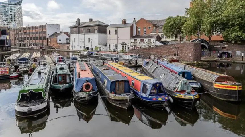
Birmingham’s canals form one of Britain’s most important surviving industrial-waterway landscapes. They connect the city centre with former manufacturing districts, Black Country industrial settlements, historic wharves, warehouses, bridges and modern waterfront developments.
- What makes Birmingham’s canals historically important?
- When were Birmingham’s canals built?
- How did canals transform Birmingham during the Industrial Revolution?
- Which canal areas best reveal Birmingham’s industrial history?
- How did Digbeth develop around Birmingham’s canals?
- What role did canal engineering play in Birmingham’s growth?
- Why did Birmingham’s canals decline after the Industrial Revolution?
- How were Birmingham’s canals preserved and regenerated?
- How can you explore Birmingham’s canals on foot?
- What should you look for when studying Birmingham’s canal heritage?
- How do Birmingham’s canals connect industrial history with the modern city?
- What is the long-term historical significance of Birmingham’s canals?
- Frequently Asked Question
Today, the waterways provide walking routes, cycling corridors, boating facilities and access to industrial heritage. Their historical importance rests on their role in Birmingham’s transformation from an eighteenth-century manufacturing town into a major industrial city.
Birmingham City Council records about 35 miles of canals within the city, while the wider Birmingham Canal Navigations (BCN) network extends for more than 100 navigable miles today. At its historical maximum, the BCN contained roughly 160 miles of waterways.
The canal landscape therefore represents more than a recreational attraction. It is surviving infrastructure from the Industrial Revolution, with engineering structures, industrial buildings and transport routes that explain how Birmingham developed.
What makes Birmingham’s canals historically important?
Birmingham’s canals are historically important because they transported coal, iron and manufactured goods, connected industrial districts, supported factories and warehouses, and accelerated Birmingham’s eighteenth- and nineteenth-century industrial expansion. Their surviving structures document this transformation today.
Before the canal network expanded, Birmingham relied heavily on roads and packhorse transport. Heavy materials were expensive to move overland. Coal, metals and industrial products were particularly difficult to transport efficiently.
The construction of canals changed this economic system. Water transport reduced the cost of moving heavy cargo and connected Birmingham with coalfields, manufacturing districts and national waterways.
The first Birmingham canal was associated with the Birmingham Canal, authorised by Parliament in 1768. James Brindley surveyed the route, and construction produced a waterway between Wednesbury and Birmingham in 1769. The route was subsequently extended towards Wolverhampton.
James Brindley was an eighteenth-century engineer whose work helped establish canal engineering as a major component of Britain’s industrial infrastructure. Matthew Boulton and other members of the Lunar Society supported the Birmingham canal project.
Birmingham’s geographical position increased the importance of the network. The city stood within reach of coalfields and manufacturing districts but lacked a navigable river capable of carrying the required industrial traffic.
The canals solved this transport problem through artificial waterways, locks, basins, bridges, wharves and aqueducts.
The resulting network became known as the Birmingham Canal Navigations. Historic England records that the BCN eventually developed into a network connecting Birmingham, Wolverhampton and the eastern Black Country. At its peak, the system contained about 159 miles of canals, alongside hundreds of wharves, private branches and basins.
When were Birmingham’s canals built?
Birmingham’s canal-building period began in the 1760s and expanded rapidly through the late eighteenth and nineteenth centuries. The Birmingham Canal opened in 1769, Birmingham and Fazeley Canal followed in 1789, and the Digbeth Branch reached completion in 1799.
The canal network developed in stages rather than through one single construction programme.
The first major project followed the failure of plans for the Trent and Mersey Canal to create a Birmingham branch. Local interests then promoted a direct connection between Birmingham and the Staffordshire and Worcestershire Canal.
The Birmingham Canal received its Act of Parliament in 1768. Brindley became engineer, with Robert Whitworth and Samuel Simcock assisting. The first section reached Birmingham in 1769.
The Birmingham and Fazeley Canal represented another major stage. Birmingham City Council records its completion in 1789, creating an important connection towards the Coventry Canal and waterways leading eastwards.
The Digbeth Branch Canal was completed in 1799. It connected Aston Junction with Warwick Bar and helped integrate the eastern side of Birmingham into the expanding canal system.
The Warwick and Birmingham Canal was also authorised in 1793 and completed in 1799. It ran approximately 22 miles between the Digbeth Branch and Saltisford Wharf at Warwick. Its infrastructure included 34 locks, an aqueduct over the River Rea and a tunnel at Shrewley.
The Worcester and Birmingham Canal received its Act in 1791 and opened throughout in 1815. Its purpose was to establish a shorter connection between Birmingham and the River Severn.
The Stratford-upon-Avon Canal was authorised in 1793. It eventually connected with the Warwick and Birmingham Canal and reached the River Avon at Stratford in 1816.
These projects created the interconnected waterway landscape visible around Birmingham today.
How did canals transform Birmingham during the Industrial Revolution?
Canals transformed Birmingham by lowering transport costs, supplying factories with coal and raw materials, connecting manufacturers with markets, and creating new industrial land around wharves, basins and waterways. They became essential infrastructure for Birmingham’s manufacturing economy.
The Industrial Revolution increased demand for reliable transport.
Birmingham specialised in industries including metalworking, engineering, manufacturing and later chemical and consumer industries. These activities required large quantities of coal, iron, timber and other materials.
Canals provided a dependable method of moving heavy cargo.
Coal became particularly important. Birmingham’s manufacturing economy depended on fuel for furnaces, steam engines and other industrial processes. Canal connections linked the city with coal-producing districts in the Black Country and Staffordshire.
The waterways also carried finished goods away from Birmingham.
Canals therefore operated as two-way industrial infrastructure. Raw materials entered the city while manufactured products travelled towards regional and national markets.
Wharves became interfaces between water transport and factories. Warehouses were constructed beside canals so goods could be unloaded, stored and transferred.
This relationship changed the physical structure of Birmingham.
Industrial premises increasingly occupied canal-side land. Streets, bridges and buildings were designed around waterways. Digbeth provides a particularly clear example.
Historic England’s research describes Digbeth as a landscape shaped by the River Rea, canals, roads and railways. The arrival of the Birmingham and Fazeley Canal and Warwick and Birmingham Canal encouraged industrial and commercial development around the earlier settlement.
The canals therefore did not simply serve Birmingham’s industrial growth. They helped determine where that growth occurred.
Which canal areas best reveal Birmingham’s industrial history?
Gas Street Basin, Brindleyplace, the Worcester and Birmingham Canal, the Digbeth Branch and Warwick Bar provide some of Birmingham’s clearest surviving canal landscapes. Their warehouses, bridges, locks, towpaths and industrial buildings connect present-day urban spaces with eighteenth- and nineteenth-century industry.
Gas Street Basin is one of the most significant historic canal locations in central Birmingham.
The basin sits close to the meeting point of major waterways and developed as an important transport and commercial space. Historic buildings around Gas Street retain evidence of canal-related activity.
Several listed structures survive in this area. Historic England records an early nineteenth-century building at Gas Street that probably served the Worcester and Birmingham Canal Company. Its canal-facing elevation demonstrates how buildings were physically integrated with the waterway.
The Holliday Street Canal Aqueduct provides another important engineering landmark. Dating from 1870, the Grade II-listed structure carries the canal from Gas Street Basin over Holliday Street. Its cast-iron framework and brick vault construction demonstrate the engineering requirements of integrating canals with expanding urban roads.
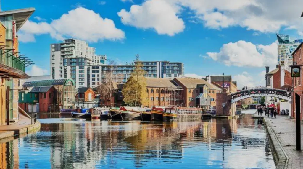
Brindleyplace represents the later transformation of the canal environment.
The area contains modern offices, restaurants, public spaces and pedestrian routes beside historic waterways. Its development illustrates the twentieth- and twenty-first-century transition from industrial infrastructure to urban regeneration.
A visitor walking west and east from Gas Street Basin encounters different layers of Birmingham’s history. Modern waterfront architecture stands alongside nineteenth-century canal infrastructure.
The eastern route towards Digbeth provides an even stronger industrial context.
Warwick Bar retains a Grade II-listed canal-side warehouse dating from around 1840. The building has red-brick construction, cast-iron columns and a relationship with the lock and wharf beside it.
These structures demonstrate how canal transport influenced architecture. Warehouses required loading points, storage spaces and direct access to boats. Their dimensions and openings reflected the movement of goods between water and land.
How did Digbeth develop around Birmingham’s canals?
Digbeth developed as a transport and industrial district because canals joined its existing roads and River Rea corridor with Birmingham’s wider manufacturing network. Canal construction encouraged warehouses, factories, streets and commercial premises, creating a layered industrial landscape that survives today.
Digbeth has a much older history than its canal infrastructure.
During the medieval period, Digbeth and neighbouring Deritend stood along an important approach to Birmingham’s settlement. The River Rea provided water and the road connected the district with the marketplace around the Bull Ring.
Metalworking became important before the Industrial Revolution. The antiquary John Leland described smiths and cutlers in the area during his 1538 observations of Birmingham.
The canal system introduced a new phase of development.
The Birmingham and Fazeley Canal entered the area during the late eighteenth century. The Warwick and Birmingham Canal followed during the 1790s. These routes created new transport connections and encouraged industrial and commercial expansion.
Historic England identifies canals, railways, roads and the River Rea as major elements in Digbeth’s historical development.
Canal construction also influenced the street plan.
New streets developed between waterways and the earlier High Street settlement. Industrial buildings and houses occupied plots shaped by canal routes.
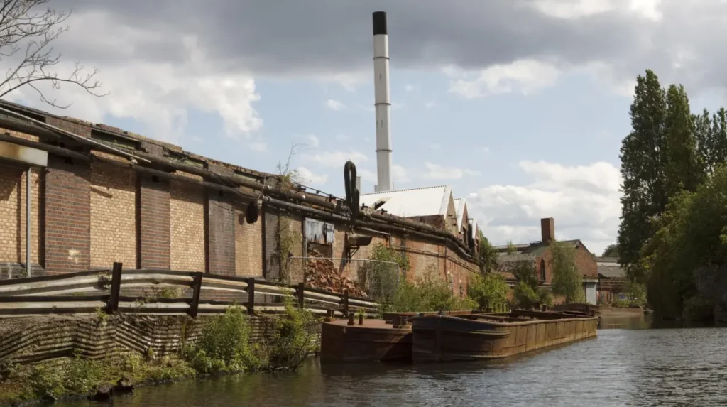
The nineteenth century added further infrastructure. Railways arrived and created another layer of transport connections. The result was an unusually dense combination of canals, railway viaducts, roads, industrial buildings and waterways.
This layered landscape is one reason Digbeth has significant heritage value.
Historic England’s 147-page Historic Area Assessment examines Digbeth and Deritend’s archaeological, architectural and historical development and identifies the area’s industrial heritage as a major component of its significance.
For visitors, the canal corridor provides a direct way to understand this historical process because the waterways remain physically present.
What role did canal engineering play in Birmingham’s growth?
Canal engineering enabled waterways to cross Birmingham’s uneven terrain through locks, aqueducts, bridges, tunnels and reservoirs. These structures controlled water levels, connected separate routes and allowed heavy industrial traffic to move through a densely developing urban environment.
Canals are engineered transport systems rather than simple artificial rivers.
Locks allow boats to move between different water levels. Birmingham’s expanding network required numerous locks because waterways crossed varied terrain.
Aqueducts carried canals over roads and rivers.
The Holliday Street Canal Aqueduct demonstrates this principle in central Birmingham. Its 1870 structure carried the canal over Holliday Street while allowing road traffic to pass underneath.
Water supply presented another engineering challenge.
The Worcester and Birmingham Canal provides a clear historical example. Water shortages generated disputes with connecting canals. The canal was initially separated from the Birmingham Canal by Worcester Bar, before a compromise eventually allowed the waterways to connect through a lock in 1815.
Thomas Telford later became important in Birmingham’s canal history.
During the 1820s, Telford inspected Birmingham’s canals after significant maintenance problems had developed. He recommended extensive improvements, including straightening sections of the network. Birmingham City Council identifies this work as a major stage in the evolution of the system.
The resulting New Main Line became a major engineering intervention.
The historic Old Main Line retained winding sections while Thomas Telford’s New Main Line created a straighter route. Canal & River Trust describes surviving loops of the Old Main Line as artificial oxbow-like backwaters created by the replacement route.
This engineering history remains visible to people walking Birmingham’s towpaths.
Why did Birmingham’s canals decline after the Industrial Revolution?
Birmingham’s canals declined because railways, roads and changing industrial practices reduced their competitive advantage. Commercial traffic continued for decades, but declining industrial demand eventually caused most freight activity to disappear and commercial canal use ended in Birmingham by 1980.
The canals remained economically significant long after their eighteenth-century construction.
Birmingham City Council records that canal traffic remained active for approximately 170 years. The tonnage of goods carried reached about 8.5 million tonnes in 1898.
Railways changed the transport market during the nineteenth century.
Rail transport provided faster connections for many types of freight and passengers. Canal companies faced increasing competition and some waterways came under railway ownership.
The Canal & River Trust explains that railway competition contributed to the decline of canal companies, while the national network subsequently contracted significantly.
Road transport created another challenge during the twentieth century.
Lorries provided direct factory-to-destination transport without requiring transshipment between canal and road. Industrial production also changed, reducing the need for canal-side coal deliveries.
The national canal system was nationalised in 1948 under the British Transport Commission. Responsibility later passed to the British Waterways Board in 1962.
Birmingham’s commercial canal traffic eventually declined to the point where all commercial traffic had stopped by 1980, according to Birmingham City Council.
The physical infrastructure remained.
Locks, bridges, warehouses, towpaths and basins survived even after their original industrial functions disappeared.
This survival created the foundation for later heritage conservation and urban regeneration.
How were Birmingham’s canals preserved and regenerated?
Birmingham’s canals were preserved through restoration, heritage protection, environmental improvements and redevelopment of former industrial land. Since the 1990s, canal-side regeneration has transformed neglected waterways into public spaces while retaining historic buildings and engineering structures.
The decline of commercial traffic initially left many canal environments neglected.
Some waterways became associated with derelict factories, unused warehouses and deteriorating infrastructure. Yet their industrial heritage remained embedded in the urban landscape.
From the 1990s onwards, canal restoration became part of wider urban regeneration.
The Canal & River Trust identifies the 1990s and 2000s as a period when governments and regeneration programmes increasingly recognised canals as assets for city-centre redevelopment. Restoration funding and improvements to canal-side environments helped create new public spaces and development opportunities.
Birmingham followed this wider national pattern.
Former industrial land beside waterways became suitable for offices, housing, leisure facilities and public spaces. The transformation of Brindleyplace is a major example of this process.
The city also developed planning guidance for the canal corridor. Birmingham City Council’s City Centre Canal Corridor Development Framework covers the corridor between Granville Street and Warwick Bar in Digbeth.
Heritage protection operates alongside regeneration.
Listed buildings retain legal protection because of their architectural or historic interest. The Warwick Bar canal warehouse is Grade II listed, as are other structures around Birmingham’s waterways.
This approach preserves individual structures while allowing their surroundings to adapt.
The result is a historic landscape in which industrial buildings and modern developments occupy the same waterfront.
How can you explore Birmingham’s canals on foot?
The most effective walking approach is to begin around Gas Street Basin, follow the towpath through Brindleyplace, continue towards the city’s eastern waterways and extend the route into Digbeth. This sequence reveals historic engineering, warehouses and regeneration.
Gas Street Basin provides a practical starting point because several important waterways converge near Birmingham city centre.
From the basin, the towpath passes through the modern Brindleyplace district. Historic canal infrastructure remains visible alongside contemporary buildings.
The route then allows visitors to examine the relationship between canals and Birmingham’s central urban development.
Continue east towards the Digbeth area to encounter a different architectural environment.
The landscape becomes increasingly industrial in character. Former warehouses, bridges, canal-side structures and railway infrastructure demonstrate how transportation shaped the district.
Warwick Bar is particularly important for heritage researchers because its surviving warehouse, stop lock and dock provide direct evidence of nineteenth-century canal commerce.
The canal route also connects with wider Birmingham waterways.
The Birmingham and Fazeley Canal forms part of the historic network extending towards the northeast. The Worcester and Birmingham Canal provides connections towards the southwest. The Digbeth Branch forms an important eastern connection.
Visitors interested in industrial history should observe the relationship between the waterway and surrounding buildings rather than treating the canal as an isolated feature.
Look for loading openings, warehouses, bridges, lock chambers, towpaths and canal-level doors.
These details explain how goods once moved from boats into industrial premises.
To experience this historic landscape in person today, consult our comprehensive [Best Canal Walks and Waterfront Attractions Across Birmingham City] for itineraries and visiting parameters.
What should you look for when studying Birmingham’s canal heritage?
Visitors studying Birmingham’s canal heritage should examine locks, aqueducts, warehouses, bridges, wharves, canal basins, towpaths and industrial buildings. These features reveal how water transport operated and how industrial architecture adapted to canal-based movement of goods.
A canal walk becomes more historically informative when its infrastructure is read as evidence.
Locks demonstrate water-level management.
Towpaths reveal how horses and workers moved boats.
Wharves identify points where cargo transferred between boats and buildings.
Warehouse openings often indicate loading arrangements. Canal-facing doors and large openings allowed goods to move directly from boats into storage spaces.
Listed buildings provide particularly valuable evidence.
The Warwick Bar warehouse, for example, retains architectural features associated with its canal-side industrial function. Historic England records its red-brick walls, cast-iron columns and relationship with the stop lock and dock.
Aqueducts demonstrate the integration of waterways with urban transport.
The Holliday Street Aqueduct is significant because it carries a working canal above a city road. Its 1870 construction shows how Birmingham’s infrastructure continued to adapt as the city expanded.
Researchers should also examine historical maps.
The Canal & River Trust archive contains records from canal companies, including plans, land ownership documents and administrative records. Its collection includes Birmingham Canal Navigation records dating from 1769 onwards.
These sources allow researchers to compare historic routes with surviving infrastructure.
How do Birmingham’s canals connect industrial history with the modern city?
Birmingham’s canals connect industrial history with the modern city because former freight routes now function as public spaces, walking corridors, boating routes and regeneration zones. Historic waterways remain active parts of Birmingham’s urban structure rather than isolated museum exhibits.
The transformation from freight infrastructure to public amenity represents one of the most important chapters in Birmingham’s canal history.
The canals no longer perform the same economic role that they performed during the Industrial Revolution. Their physical presence, however, continues to shape the city.
Modern canal-side districts use historic waterways as organising features.
Brindleyplace demonstrates how former industrial waterfronts became mixed-use urban districts. Digbeth demonstrates a different model, where historic industrial buildings coexist with creative, cultural and commercial activity.
Historic England describes Digbeth as a multi-layered environment in which canals, railways, roads and industrial buildings contribute to the area’s distinctive character.
The canal network also remains a significant regional infrastructure system.
The Birmingham Canal Navigations extend beyond the city into the wider West Midlands. Canal & River Trust records more than 100 navigable miles within the modern BCN system.
This regional scale is important when interpreting Birmingham’s history.
The waterways connected Birmingham with the Black Country, Staffordshire, Warwickshire, Worcestershire and the wider national canal system.
Their historical function was therefore regional rather than purely local.
What is the long-term historical significance of Birmingham’s canals?
The long-term significance of Birmingham’s canals lies in their surviving evidence of industrialisation, engineering, commerce, urban growth and regeneration. They preserve the physical framework through which Birmingham became a major manufacturing centre and continue to shape its modern identity.
Birmingham’s canals provide direct evidence of the city’s industrial transformation.
The first canal arrived in 1769, when Birmingham was entering a period of rapid industrial expansion. Subsequent waterways connected the city to coalfields, manufacturing districts and national transport routes.
The network expanded to approximately 160 miles at its historical maximum.
Its importance is visible in surviving buildings.
Warehouses demonstrate commercial activity. Locks demonstrate hydraulic engineering. Aqueducts demonstrate infrastructure integration. Towpaths demonstrate the working environment of canal transport.
The decline of canal freight did not erase these structures.
Instead, the waterways entered a new historical phase.
Restoration and regeneration converted former industrial corridors into public and commercial environments. This created a distinctive urban landscape where eighteenth-century engineering stands beside twentieth- and twenty-first-century architecture.
For historians and educators, Birmingham’s canals provide a practical case study of industrialisation.
For cultural tourists, they provide access to surviving industrial structures within walking distance of the city centre.
For heritage researchers, they preserve evidence that links transport infrastructure with industrial architecture and urban development.
For genealogical researchers, canal-side districts provide useful geographical context for understanding the working environments inhabited by past generations. Canal companies, industrial businesses, warehouses and surrounding streets formed interconnected employment and residential landscapes.
The canals therefore remain historically relevant because their story did not end when commercial freight disappeared.
They document the causes of Birmingham’s industrial growth, the infrastructure that sustained it, the transport competition that contributed to its decline and the regeneration policies that returned waterways to public prominence.
Birmingham’s canal network is consequently best understood as a continuous historical landscape. Its eighteenth-century construction, nineteenth-century industrial expansion, twentieth-century decline and modern regeneration form connected stages of the city’s development.
Walking beside the waterways today provides direct access to this layered history. The surviving canal corridors, locks, warehouses, aqueducts and wharves remain physical records of the economic and architectural transformation that made Birmingham one of Britain’s major industrial cities.
Frequently Asked Question
What is the history of Birmingham’s canals?
Birmingham’s canal network began expanding in the 18th century. The first Birmingham Canal opened in 1769, connecting the city with Wednesbury and the Staffordshire coalfields. The network later expanded into the Birmingham Canal Navigations, supporting industrial growth.