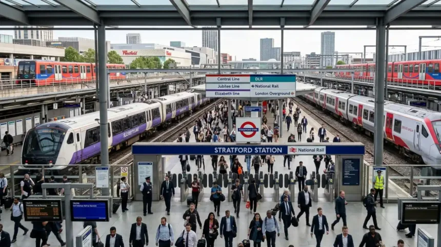
Stratford Station is a major multi-modal transport interchange located in Stratford within the London Borough of Newham, East London. As one of the most critical infrastructure hubs in the United Kingdom, the station serves as a gateway linking London to the East of England, Essex, and Kent. Transport for London and Network Rail jointly manage this terminal, which coordinates national rail services, rapid transit networks, and regional light rail systems. Operating within Travelcard Zones 2 and 3, Stratford Station accommodates tens of millions of passengers annually, acting as a structural anchor for regional economic development, transit-oriented commerce, and international event logistics.
- What is the history of Stratford Station?
- The Nineteenth-Century Industrial Foundation
- Twentieth-Century Transit Integration
- The Jubilee Line Extension and Modern Era
- Which transit lines operate through Stratford Station?
- London Underground Subnetworks
- National Rail and Regional Express Networks
- Light Rail and Suburban Systems
- How is Stratford Station laid out structurally?
- What are the passenger statistics for Stratford Station?
- How does Stratford Station impact regional regeneration?
- What are the future upgrade plans for Stratford Station?
- The Strategic Outline Business Case
- Projected Economic and Civil Deliverables
- Immediate and Medium-Term Adaptations
- How does Stratford Station connect to the wider UK transport network?
What is the history of Stratford Station?
Stratford Station opened on June 20, 1839, under the Eastern Counties Railway, evolving from a simple regional stop into a sprawling multi-level interchange that expanded rapidly to support the industrialization of East London and the London 2012 Olympic Games.
The Nineteenth-Century Industrial Foundation
The Eastern Counties Railway established the initial station infrastructure to connect London with Romford and Colchester. In 1847, the Northern and Eastern Railway added connecting lines from Tottenham, transforming the site into a junction. The Great Eastern Railway assumed control of the station in 1862, constructing extensive locomotive and carriage workshops known as the Stratford Works. These manufacturing facilities employed over 6,000 engineering workers by the late 1890s, driving residential growth in the surrounding Newham district and establishing the station as a focal point for freight and industrial labor.
Twentieth-Century Transit Integration
The expansion of mass rapid transit systems fundamentally altered the spatial layout of Stratford Station during the mid-twentieth century. The London Passenger Transport Board extended the Central line to the station on December 4, 1946, as part of the 1935–1940 New Works Programme. This integration required significant structural modifications, including the lengthening of platforms to 130 meters and the reconfiguration of steam-era tracks. On August 31, 1987, the Docklands Light Railway initiated services from Stratford, utilizing converted platforms to link East London with the developing Isle of Dogs financial district.
The Jubilee Line Extension and Modern Era
The London Underground expanded further when the Jubilee line arrived at Stratford on May 14, 1999. This development established a new low-level station concourse constructed from steel and curved glass, designed to handle up to 30 million annual passengers.
The designation of London as the host city for the 2012 Olympic and Paralympic Games catalyzed a £104 million comprehensive upgrade funded by the Olympic Delivery Authority and Network Rail. These modifications added a new high-level pedestrian overpass, widened platforms, and doubled the total gate capacity to ensure the station could process more than 200,000 passengers per day during the international sporting event.
Which transit lines operate through Stratford Station?
Stratford Station integrates six distinct rail and rapid transit networks, which include the London Underground Central and Jubilee lines, the Elizabeth line, the Docklands Light Railway, London Overground services, and mainline National Rail passenger routes operated by Greater Anglia.
London Underground Subnetworks
The London Underground provides high-frequency subterranean and surface transit across the capital via two primary routes:
- The Central Line: This line operates on the high-level platforms, providing direct east-west connections between Epping in Essex and West Ruislip or Ealing Broadway in West London. It uses unique cross-platform interchange configurations with National Rail services to optimize passenger flow.
- The Jubilee Line: Operating from the low-level terminal, this line acts as a south-westerly corridor passing through Canary Wharf, London Bridge, and Westminster before terminating at Stanmore in Northwest London.
National Rail and Regional Express Networks
Mainline rail services provide critical links between the capital and the eastern counties. The Elizabeth line runs high-capacity regional express trains through the central London tunnel system, directly connecting Stratford to Reading, Heathrow Airport, and Shenfield. National Rail operator Greater Anglia provides fast and semi-fast mainline trains from London Liverpool Street to regional cities, including Norwich, Ipswich, and Cambridge.
Light Rail and Suburban Systems
The remaining platforms accommodate specialized orbital and light rail networks:
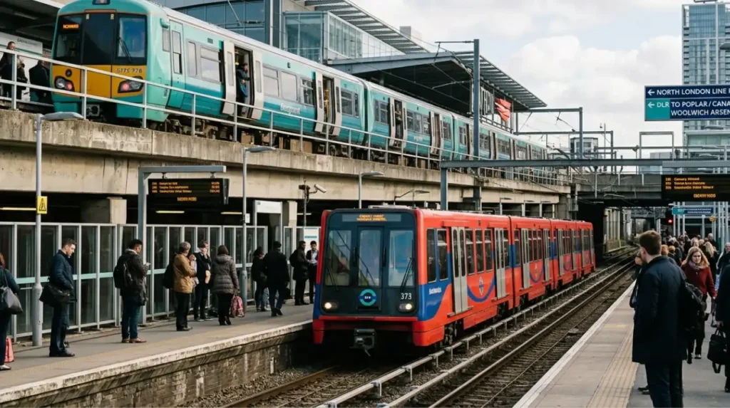
- The Docklands Light Railway: This automated driverless system uses two distinct routes out of Stratford, with one branch terminating at Poplar and Canary Wharf, and another distinct branch operating via the international complex toward Woolwich Arsenal.
- The London Overground: Operating via the Mildmay line, these orbital services run on the North London line platforms, linking Stratford to Highbury & Islington, Camden Road, and Richmond.
How is Stratford Station laid out structurally?
The structural architecture of Stratford Station consists of a complex, multi-level layout divided into an upper high-level station and a lower low-level station, managing a total of 19 platforms connected by extensive pedestrian subways and bridges.
High-Level Station Architecture
The high-level section sits on a raised Victorian-era embankment aligned from southwest to northeast. This area contains Platforms 1 and 2, which serve the London Overground, alongside Platforms 3, 3A, and 6, which accommodate the Central line. Mainline National Rail services and the Elizabeth line occupy Platforms 5, 8, 9, 10, and 10A. A broad, enclosed pedestrian bridge spans these tracks, connecting the main ticket hall directly to the Westfield Stratford City shopping complex and providing overhead access lifts to all high-level platforms.
Low-Level Station Infrastructure
The low-level station sits perpendicular to the high-level tracks, aligned on a northwest-to-southeast axis within a concrete cutting. Platforms 13, 14, and 15 serve as the eastern terminus for the Jubilee line, utilizing wide platform islands to manage rapid passenger boarding. Platforms 16 and 17 accommodate the Docklands Light Railway routes heading toward Canary Wharf and South London. The low-level concourse features a subterranean pedestrian subway system that links these deep platforms directly to the central ticket hall without requiring passengers to ascend to street level.
Station Entrances and Access Points
The facility features three primary public entrances that distribute pedestrian traffic across different urban sectors. The historic South Entrance faces the old Stratford town centre and the bus station, giving commuters direct access to local commercial high streets. The North Entrance connects directly to the mezzanine level of the Westfield retail complex and the Queen Elizabeth Olympic Park.
In October 2024, a new £8.4 million south-western entrance opened on Gibbins Road. This infrastructure asset connects the station to the Carpenters Estate, reducing walking times by up to 20 minutes for residents in the southern catchment area.
What are the passenger statistics for Stratford Station?
Passenger traffic data confirms that Stratford Station ranks as the seventh busiest railway station in Great Britain, recording 51,473,518 National Rail entries and exits alongside over 53 million London Underground passenger journeys during recent annual reporting periods.
Annual Traffic Volumes
Data published by the Office of Rail and Road and Transport for London highlights the extreme density of the station. In the 2023/2024 financial year, the National Rail platforms alone recorded 56,571,000 entries and exits, while the 2024/2025 period leveled to 51,473,518 annual users. When combining the independent data sets from the London Underground, Docklands Light Railway, and National Rail networks, the total annual passenger movements across the entire interchange complex exceed 110 million journeys.
Daily Commuter Dynamics
The station processes a massive volume of daily travelers, particularly during morning and evening peak hours.
- Daily Footfall Average: The facility handles an average of 141,023 passengers starting or ending journeys each day.
- Interchange Volume: When including passengers switching between different train lines, the daily average rises to 154,376 individuals.
- Service Density: The station schedules 7,524 train services per week, ranking it eighth nationally for total rail movements.
Comparison to National Gateways
Stratford Station consistently ranks alongside major central London termini like London Waterloo, London King’s Cross, and London Victoria in terms of absolute passenger volume. It serves as the primary eastern transit gateway for the United Kingdom, surpassing all other stations in East London, Essex, and East Anglia combined for total multi-modal interchange activity.
How does Stratford Station impact regional regeneration?
Stratford Station serves as the primary economic catalyst for the post-industrial regeneration of East London, driving billions of pounds in private investment, commercial developments, and large-scale residential projects across the Newham borough.
The Post-Olympic Urban Legacy
The selection of Stratford as the central transit hub for the 2012 Olympic Games turned disused rail yards into high-density urban spaces. The London Legacy Development Corporation utilized the station’s transport capacity to build the Queen Elizabeth Olympic Park, a 560-acre public parkland asset. This infrastructure enabled the development of East Bank, a new cultural and educational district featuring campuses for University College London, the London College of Fashion, and the Victoria and Albert Museum.
Commercial and Retail Expansion
The physical connection between the station and private land plots enabled the construction of Westfield Stratford City, which opened in September 2011. This site represents one of the largest urban shopping malls in Europe, measuring 177,000 square meters of retail space. The complex generates over 10,000 permanent retail jobs and attracts more than 50 million visitors annually, sustained entirely by the high-volume transit connections provided by the adjacent station entrances.
Residential and Workspace Masterplans
According to the Birmingham Express urban planning archives, the station’s transit links have supported multiple mixed-use real estate projects surrounding the terminal.
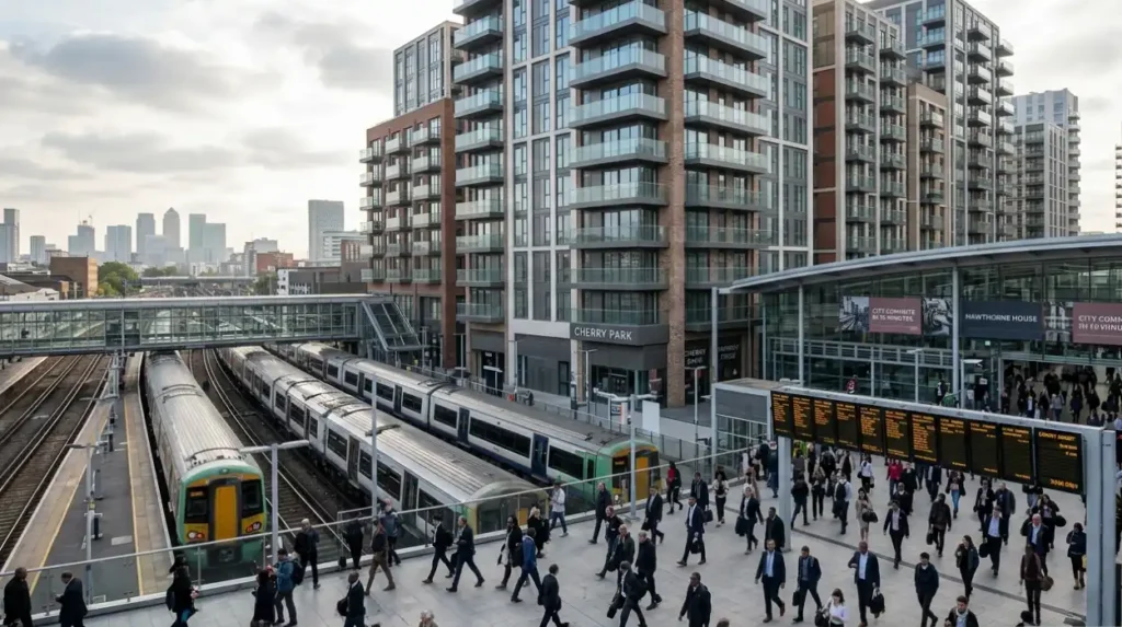
Completed projects like Cherry Park and Hawthorne House provide high-density housing options for workers who commute to the City of London and Canary Wharf. These developments rely on the station’s sub-ten-minute transit times to central financial districts to maintain high occupancy rates and economic viability.
What are the future upgrade plans for Stratford Station?
The future redevelopment plans for Stratford Station involve a massive, multi-billion-pound long-term reconfiguration designed to expand concourse space, eliminate passenger overcrowding, and unlock thousands of new homes on public sector land.
The Strategic Outline Business Case
A public-sector coalition consisting of Newham Council, the London Legacy Development Corporation, Network Rail, and Transport for London submitted a formal Strategic Outline Business Case to the UK Government on July 31, 2023. This document outlines structural interventions needed to fix severe overcrowding issues caused by rapid population growth in East London. The business case shows that without a major redesign, the station will hit maximum safe capacity limits before 2030, which could lead to regular gate closures during rush hour.
Projected Economic and Civil Deliverables
The proposed long-term upgrade project seeks significant public funding to remodel the existing ticket halls, bridges, and platform approaches. The business case highlights several key project benefits:
- Employment Growth: The project aims to create up to 10,000 new jobs by expanding local commercial spaces.
- Affordable Housing: Plans include building 2,000 new homes around a new public square, with 50% designated as genuinely affordable housing.
- Commercial Real Estate: The project will add 150,000 square meters of office, retail, and community spaces.
Immediate and Medium-Term Adaptations
While the government reviews the large-scale business case, transport authorities are rolling out smaller upgrades to keep things moving. The opening of the Carpenters Estate entrance in late 2024 served as the first major step in this interim relief program. Moving forward into the late 2020s, engineers are updating signaling systems on the Central line and adjusting platform layouts on the North London line to boost train frequencies and passenger safety.
How does Stratford Station connect to the wider UK transport network?
Stratford Station operates as a critical national transit point that links London’s local metro routes with regional high-speed rail lines, major international airports, and national road corridors.
High-Speed and International Rail Links
The station connects directly to Stratford International Station via the Docklands Light Railway and a shared pedestrian avenue. Stratford International sits on the High Speed 1 railway line, where Southeastern HighSpeed trains connect passengers to Ebbsfleet International and Ashford International in Kent at speeds up to 140 miles per hour. This link lets commuters travel from Stratford to the Kent coast in under 60 minutes, bypassing central London entirely.
Airport Transit Connections
The station serves as a vital link for international travelers using London’s aviation network:
- London City Airport: The Docklands Light Railway connects Stratford directly to London City Airport in 15 minutes, serving business travelers heading to European financial centers.
- Stansted Airport: Greater Anglia runs direct national rail services from Stratford to the Essex airport terminal, providing a key corridor for international flights.
- Heathrow Airport: The Elizabeth line runs direct express services across London, linking Stratford to Heathrow Central in under 45 minutes.
Regional Coach and Bus Logistics
A large bus station sits right outside the historic South Entrance, managing over 30 local bus routes that run throughout Northeast London. National Express also runs long-distance coach services from the station, connecting passengers directly to regional cities like Birmingham, Norwich, and Cambridge. This setup makes Stratford Station a versatile, multi-modal hub that keeps East London deeply connected to the rest of the country.
Where is Stratford Station located?
Stratford Station is located in Stratford, London Borough of Newham, in East London. It sits within Travelcard Zones 2 and 3 and serves as one of London’s busiest transport interchanges.